Annular Solar Eclipse
2024 October 2
This annular eclipse begins in the Equatorial Pacific, 1,600 km southwest of Hawaii, in a region of high cloudiness associated with the Intertropical Convergence Zone (ITCZ). As it turns southward, the track quickly leaves the ITCZ (Figure 1) and moves into a semi-permanent zone of high pressure known as the South Pacfic sub-tropical anticyclone . This anticyclone is a part of the global atmospheric circulation and marks a region where air, rising from the ITCZ, descends back to the surface. As the air descends, it warms and dries, giving the region between the equator and the 20th parallel a sunny and rain-free disposition. That sunny disposition is limited in extent, however, as the descending air also creates a strong temperature inversion in the lower atmosphere that traps ocean moisture in a layer close to the surface,
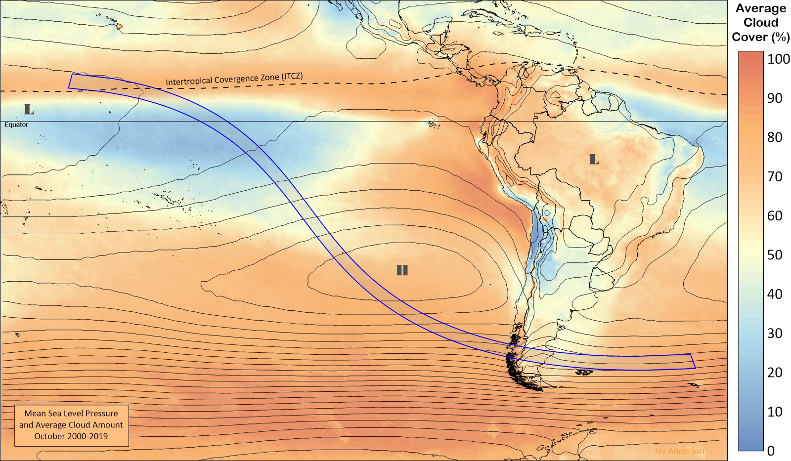
In October, the average position of the ITCZ—a region where winds from the Northern and Southern Hemispheres converge—lies about 8 degrees north of the Equator, marked in the satellite-derived cloud map of Figure 1 by a narrow band of high cloudiness. Satellite measurement of October cloudiness under the ITCZ averages 70 to 80 percent. Views from orbit show that the cloud is composed of a mixture of scattered to broken convective clouds overlain by fibrous mid- and high-level debris cloud thrown up by the convection. The satellite values seem too pessimistic, as images on eclipse day over the past 20 years show that while cloud is always present, it occurs in large clusters that are broken up by intervening skies of only thin scattered clouds. Nevertheless, the satellite-derived cloud map is useful for determining the relative cloudiness of different locations, though not the probability of seeing the eclipse.
About 1,500 km after its sunrise appearance, the track begins to turn to the southeast and moves out from under the influence of the ITCZ into the sunnier skies of the anticyclone. There is a rapid improvement in viewing prospects (Figure 3), with average monthly cloud amounts dropping to 20 percent as the shadow reaches the equator.
These favourable weather prospects linger well into southern latitudes, but then begin a steady increase that culminates at the South American coast. The track is still under the influence of the South Pacific anticyclone for most of its Pacific path, but as it approaches and then passes Rapa Nui (Easter Island), the low-level air beneath the inversion becomes filled with moisture and the cloud amounts respond. Scattered cumulus becomes broken cumulus and then turns into large sheets of broken to overcast stratocumulus (Figure 2).
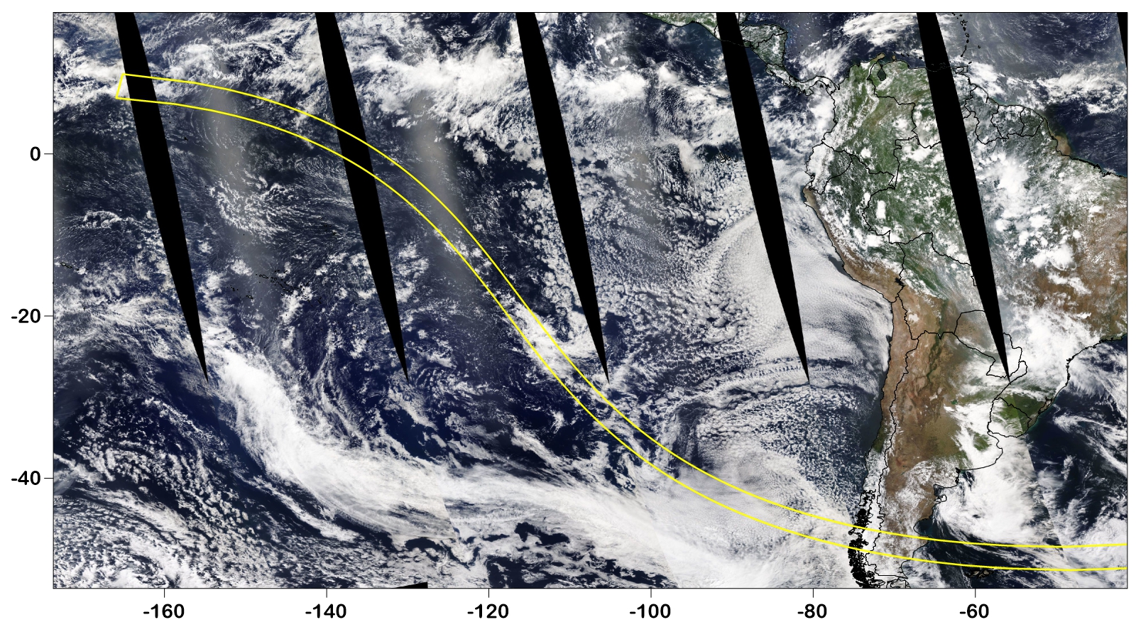
In addition to the rather abrupt increase in stratocumulus, the region from Rapa Nui southward is occasionally affected by northward remnants of cold and warm front. One is shown in Figure 2, stretching across the lower central part of the image. These systems bring rain when they arrive; the stratocumulus clouds seldom offer more than drizzle.
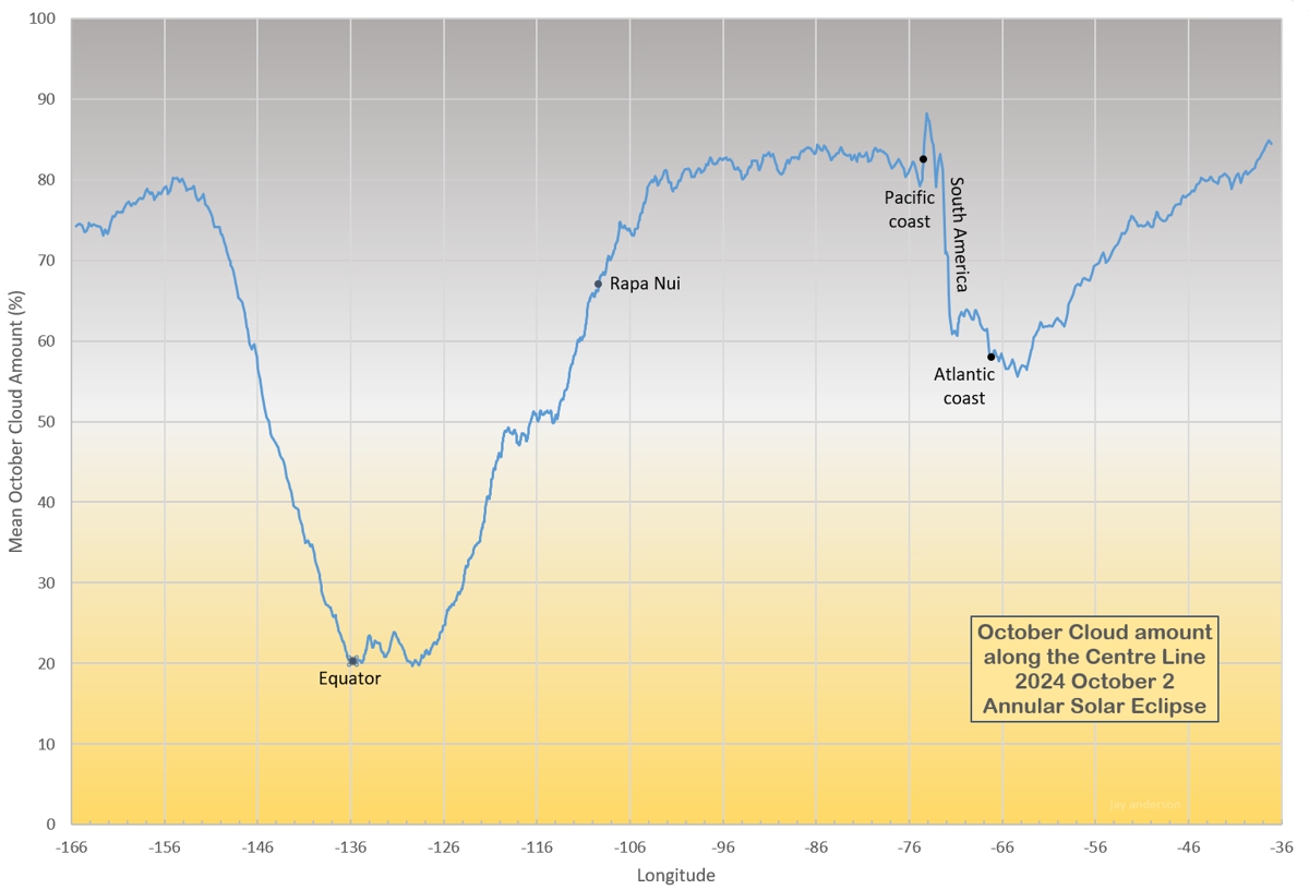
Average October cloud amounts measured from satellite increase rapidly from about 20 percent in the anticyclone to between 65 and 85 percent along the track from southeast of Rapa Nui to the South American coast. The highest values are at the coast, where westerly flows encounter the Andes Mountains and are forced to rise upward, cooling and condensing into thick and persistent layers of cloud.
On the eastern, leeward side of the Andes, the overflowing air descends onto the Argentine pampas. Ordinarily, this descending air would warm and dry, producing a region of sunny skies to the lee of the mountains. On the Argentina pampas, however, cloud often spills over the mountains, forming large sheets of cirrus and altocirrus, or bands of lee wave clouds. The pampas are a semi-arid region, but the availability of moisture from the Atlantic and the lingering influence of the mountains makes it a region of mixed cloudiness, especially in this springtime season. Nevertheless, the Argentinian side of the Andes provides the best land-based weather prospects for the eclipse. Satellite-measured cloud amounts for October range between 80 and 90 percent on the Chilean side of the continent, declining to around 55 percent in various “sweet spots” over Argentina
Rapa Nui
Rapa Nui lies at 27° south latitude, beneath the subtropical anticyclone but at a longitude where stratocumulus cloud systems begin to dominate. The stratocumulus may be organized into large blocks of cloud or form as widely scattered cumulus buidups. They are often overlain by transparent cirrus clouds, thrown up by weather systems to the south. Now-and-then, a passing front will bring extensive, deep layers of cloud and precipitation. It sounds pretty dismal, but the airport near Hanga Roa reports an average sunshine amount of 51 percent for the month, the highest along the eclipse track by a small amount (Table 1).
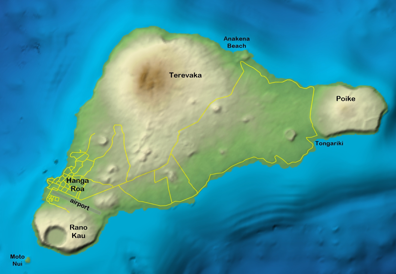
Rapa Nui also has a low but rugged terrain marked by three large, dormant volcanoes (Figure 4) and a number of smaller cones. The larger peak’s impact on the island’s cloud cover is fairly substantial, both in the generation of cloud and in its dissipation. Air flowing over the peaks, especially Terevaka, the highest, often forms cloud on the upwind side and dissipate it on the downwind. At other times, the peaks cause a series of wave clouds to form downwind. When the inversion is low and strong enough, air cannot rise over Terevaka and instead flows around it, forming a “wake” of cloud on its flanks.

In addition to terrain-induced cloud, Rapa Nui is large enough that daytime heating of the ground promotes the formation of convective clouds. These are usually shallow, thanks to the overlying anticyclone that dampens buildups, but can still bring an extensive cloud cover. During the eclipse, the cooling of the land should cause much of this convection to come to an end and clouds to dissipate, but if the cloudiness is heavy—more than 6 tenths or thereabouts, it may settle into a stratus layer that won’t dissipate until after the eclipse. In the end, Rapa Nui has left with a highly variable cloud climatology that doesn’t allow easy recommendation for an eclipse day site.
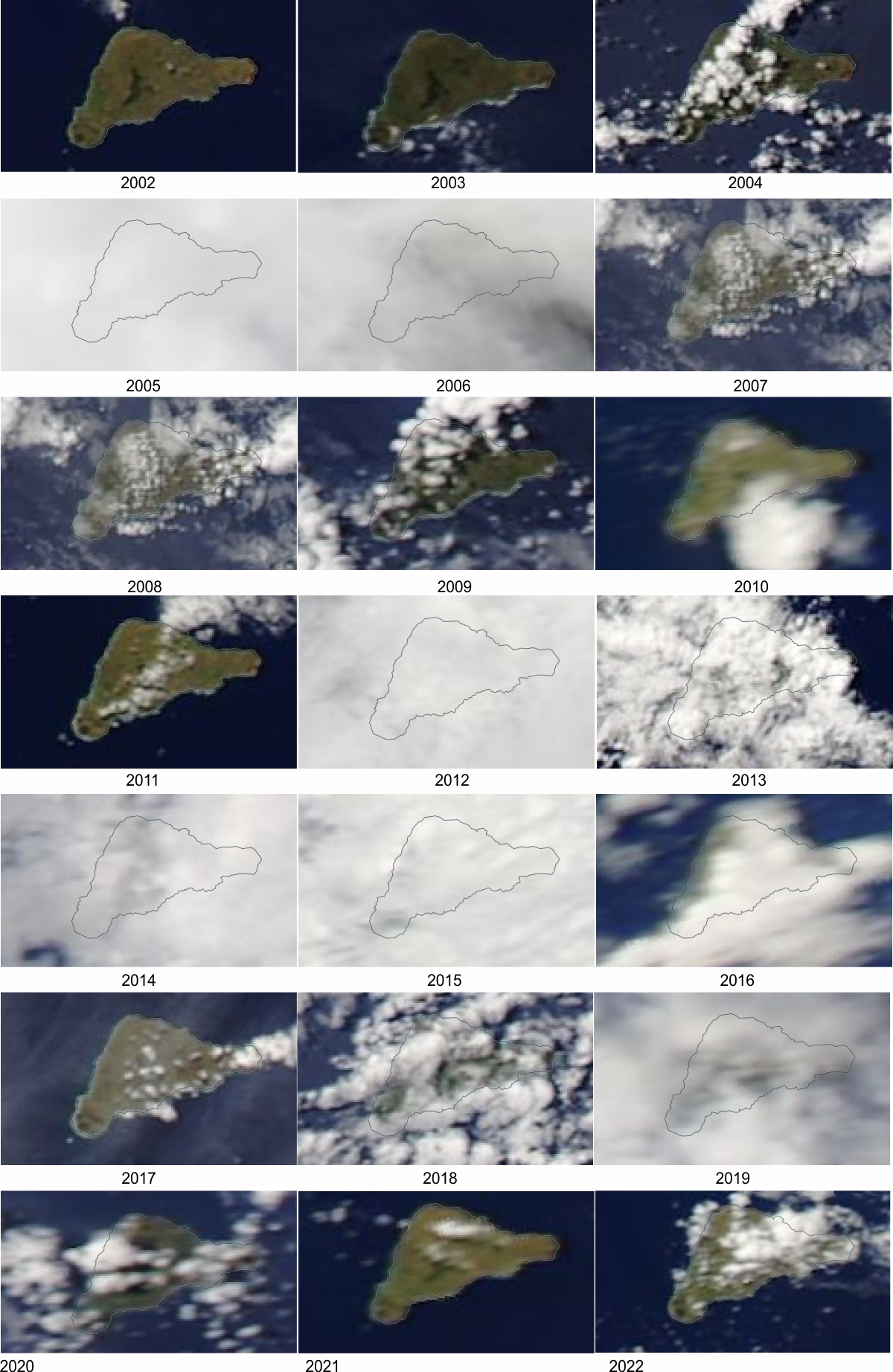
In spite of this pessimism, there are some areas more favoured than other for clear skies. Roads on the island are almost completely confined to the flatter southerly side (Figure 4) and so quick movement is mostly limited to northeast or southwest directions. Except on very cloudy days, there are often open spots somewhere on the island, though they are usually transitory unless clearly linked to the topography, such as the clearing downwind from Terevaka. Some idea of the variability of island cloud can be found in Figure 5, which hints that a south coast location may be slightly favoured for eclipse day.
South America
When the track reaches the coast of Chile, it is presented with a formidable topographic barrier (Figure 6). The coastal lowlands extend only a few kilometres inland, if at all, as the Andes rise very quickly from the ocean, reaching altitudes of 2000 to 3000 m within a hundred kilometres. In addition to the difficult access dictated by the mountains, the terrain is also cut by numerous inlets and fiords and interrumpted by mountain lakes, all of which limit the ability to move along the eclipse track. Travel into and along the shadow path is limited, but hardy adventurers will be rewarded with spectacular scenery and the knowledge that they have reached one of the world’s vacation outposts.
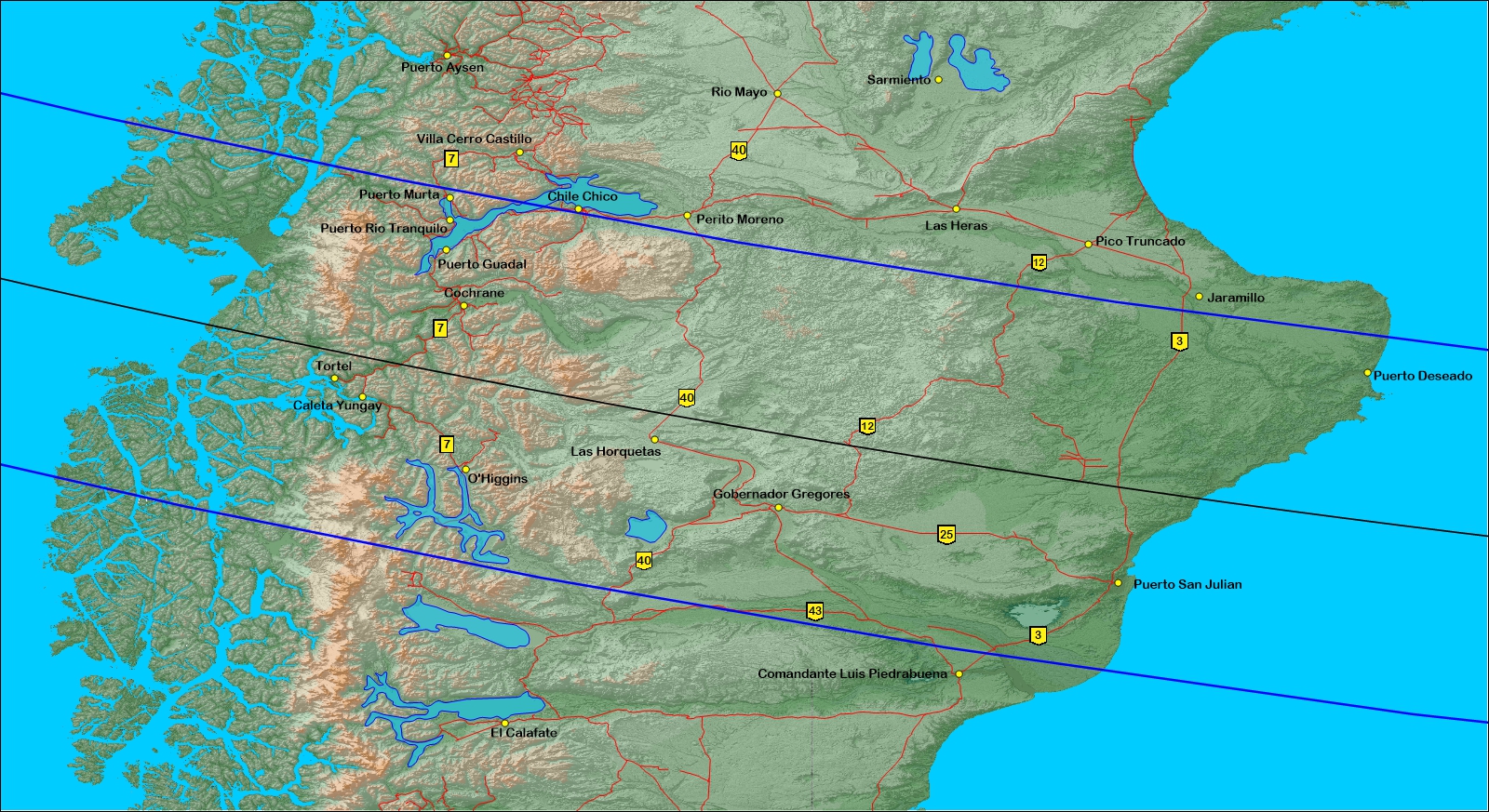
Once over the Andes and into Argentina, the lunar shadow gradually opens onto the relatively flat terrain of Argentina’s Patagonia. As the track reaches Gobernador Gregores, the terrain turns into a bland landscape, sparsely populated, but possessisng several hard-surface highways that provide a path to escape to sunnier weather on eclipse day.
Eclipse access in Chile
Reaching the eclipse zone in Chile largely involves travel on gravel, single-lane roads over long distances, winding along mountain valleys, occasionally with short rides on small ferries. Highway 7, the Carretera Austral, stretches 1,220 km from Puerto Montt in the north to O’Higgins in the south, ending after crossing about 2/3rds of the eclipse track. Except for the first 60 km, It’s a narrow gravel road so don’t expect speeds of 100 km/h. Along the way, you’ll see a smorgasborg of mountain scenery, deep valley lakes, glaciers, and plenty of cloud, and will have to ferry over several lakes. It will be spectacular.
In Chile, the main community within the eclipse track with ready accommodation is Cochrane, 75 km north of the centre line. The community lies under one of the few lower-cloud areas within the Andes; cloud amounts drop to around 60 percent in the region. Cochrane has an airport with a 1-km paved runway that can handle small aircraft. Because of the frequent bad weather in the mountains, flight schedules should adjust for delays ahead of the eclipse. About 15 km north of Cochrane, Highway X-83 from Argentina joins Highway 7, offering an easier international path into the Chilean portion of the shadow track. The flavour of an expedition along the Carretera Austral can be sampled with Earthview on Google Earth. While ordinary road maps show the major routes, invoking Earthview in Google Earth will reveal many other tracks and paths, including some via boat or on foot if you want to explore virtually or, in 2024, physically.
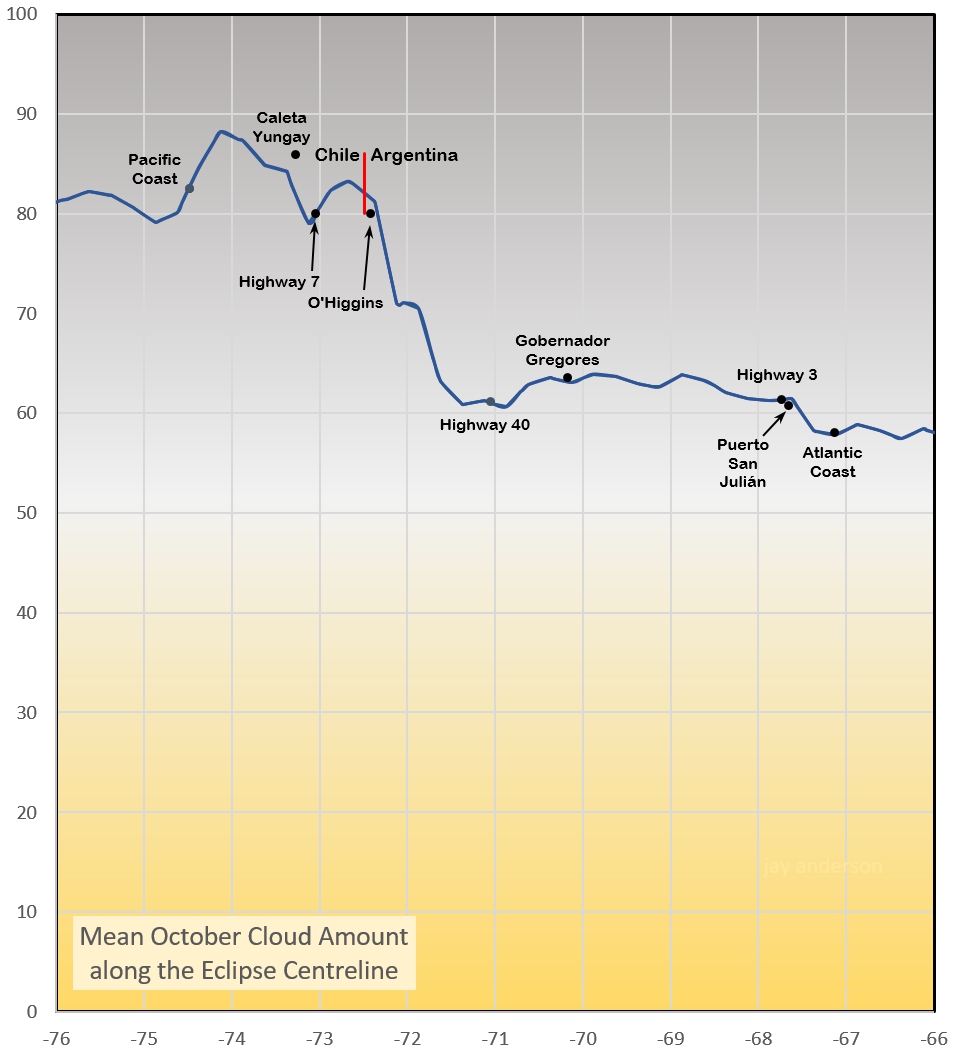
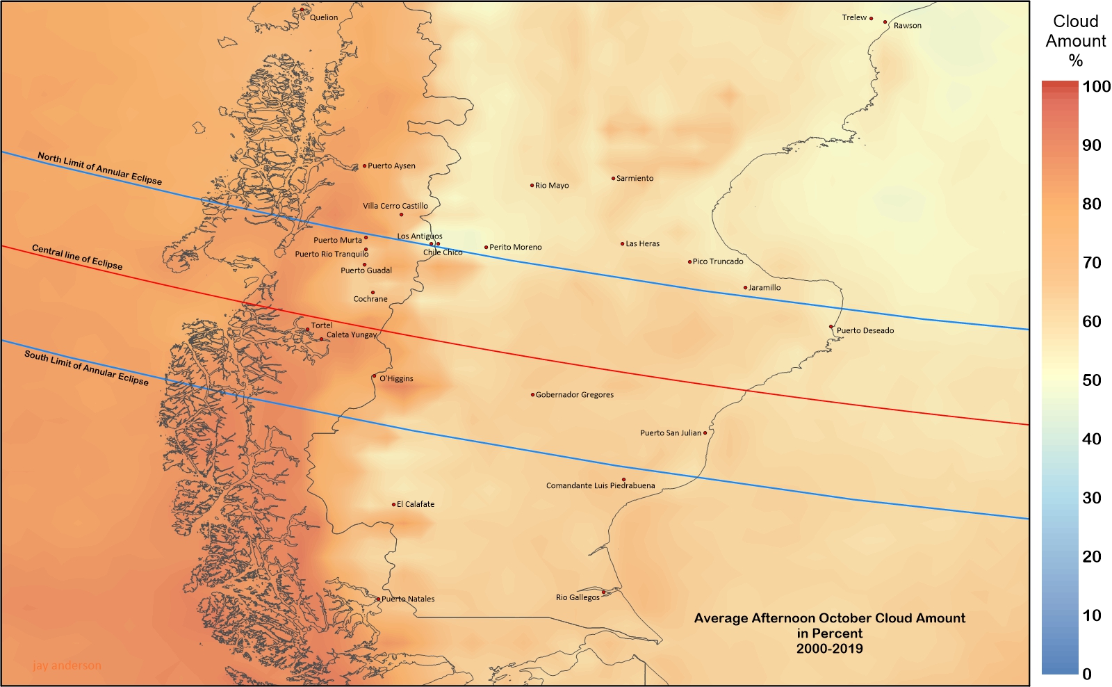
Figure 7 makes it painfully obvious that sunny skies are not a strong point in the Chilean Andes and the adjacent Argentine share of the mountain range. Where Highway 7 crosses the centreline, average cloudiness is around 80 percent, at least in the satellite’s opinion. Unfortunately, there are no sunshine statistics for any site within the Andean part of the eclipse track in Chile, so an absolute percentage of sunny skies cannot be provided. Airport observations at Cochrane show that clear or mostly clear skies are only present about 15 percent of the days at eclipse time and only 30 percent of days have less than 50 percent cloud cover. Comparison of the topographic map in Figure 6 with the cloud map in Figure 8 reveals that the highest cloud amounts lie overtop the highest terrain, so valley locations are favoured, though only by a few percent.
O’Higgins, at the end of the Carretera Austral, also sports an airport, allowing those who want to see the eclipse and then start another adventure, as the community is a centre for mountain touring .
Mountain valleys tend to eat holes in cloud, which, in the case of these mountains, are barely seen in the relatively large footprint of the satellite cloud measurements. However examination of daily images from 2000 to 2021 reveals that the eclipse would likely have been visible at the Highway 7 centreline on perhaps 10 occasions, though only four of those days were clear.
Temperatures in the mountains are on the cool side, with overnight lows averaging around +5°C; record lows drop into minus values.
The eclipse in Argentina
On the Argentine side of the Andes, the mountains give way gradually to a flat, lumpy plain and October cloudiness descends from the mid-80 percent along the Chilean border to a more tolerable 55 to 65 percent (Figure 8) on the eastern plains. The cloud map of Figure 8 shows several patches off of the centre line where October cloud tends to be a little less than their surroundings, but those values decline to only 55% or thereabouts. These lower cloud areas are associated with lower terrain on the east side of the Andes as a comparison of Figures 8 and 6 shows.
Perusal of daily satellite images reveals a cloud environment over Patagonia that is often broken up into fragments that would probably not completely obscure the eclipse, especially as annular eclipses can tolerate a bit of cloud and still be visible.
From the intersection of Highway 40 and the centre line to the Atlantic coast, there is little to commend one spot over another. The most convenient inland eclipse “base” is Gobernador Gregores, the largest city along the track, where facilities are available. Airport instruments report that an average of 43 percent of the hours in October are sunny.
An examination of past weather on eclipse day is a little more encouraging. Gobernador Gregores is close enough to the Andes that clouds that spill over the range can spread into the area. In addition, October skies are often filled with convective clouds that will make finding an observing site difficult and require short-notice movement. On the 22 eclipse days between 2000 and 2021, the annular would have been visible on 10 without moving from the city, but on all but 4 if observers were prepared to travel 50 to 100 km.
The small community (barely a road stop) at Las Horquetas, 125 km westward from Gobernador Gregores along Highway 40, lies 19 km from the centre line, provides a small hotel where a few lucky souls can take up eclipse-day residence. The centre line can also be reached from Gobernador Gregores east and then northward along Highway 12, a distance of 100 km through hummocky terrain. Both roads are unpaved as of 2014.
On the Atlantic coast, Puerto San Julián provides another starting point for eclipse seekers. The airport there measures an average of 48 percent sunshine on October days (Table 1). Except for the marginally higher value at Rapa Nui, this is most generous sunshine measurement along the track. Because of its coastal location, the port is less affected by convective clouds, but more impacted by large weather systems passing offshore to the south.
At Puerto San Julián, the eclipse would have been visible on 13 of the October 2’s between 2000 and 2021 with a further 4 days uncertain, but possible, especially with a little movement. If this limited sample is representative, the chances of seeing at least something of the eclipse from the community ranges between 60 and 77 percent.
Puerto San Julián has the distinction of being Magellan’s first important stop in his voyage around the world. A replica of one of his ships, the Nao Victoria, can be found at the waterfront in the town; it could provide an interesting foreground for eclipse images. The town’s location on the Atlantic coast gives it a more tourist-oriented personality, with many attractions not available inland. If birds are your forte, it has rheas and penguins to entertain.
From Puerto San Julián, paved highways provide convenient movement to the north, south, and west. The community itself lies 90 km south of the central axis of the track on Highway 3. The centreline to the north is a barren gravel plain with no obstructions. Selecting a location is as easy as pulling off of the road.
Another possible eclipse base is Puerto Deseado, near the north limit, but skies are cloudier in that direction (39 percent October sunshine) and reaching the centreline requires a trip well to the north, past Puerto San Julián.
The main conclusion to be drawn from the cloud climatology of the South American part of the track is to avoid the mountains and the eastern lee side. Best prospects are in the shadow track between Gobernador Gregores and the coast. Mobility will improve your prospects.
February 2024
Return to Eclipsophile home page