|
Weatherdesk 2023 |
Climatology for the Eclipse
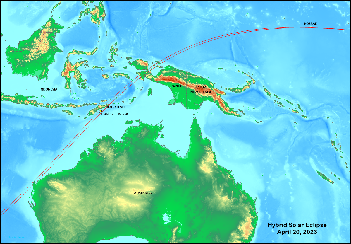
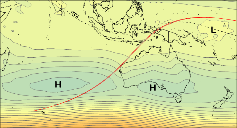
The annular/total (hybrid) eclipse of 2023 begins in the strong westerly flow of the southern temperate latitudes, crosses the dry sub-tropical anticyclone west of Australia and ends in the equatorial heat and humidity of the western Pacific islands (Figure 2). The weather and cloud patterns follow the dictates of these large-scale circulation with the best weather beneath the anticyclone and poorer prospects at the east and west limits. Most of this eclipse track lies over water, with only a small touch on the Australian coast and a number of short crossings on various Indonesian islands and the island of East Timor (Timor-Leste).
At its sunrise start, the Moon’s umbral shadow touches the Earth deep in the Southern Hemisphere’s temperate zone weather, about 350 km west of the Kerguelen Islands. The umbral part of the lunar shadow falls just short of reaching the Earth’s surface and so the eclipse is a very narrow annular at this point. About 700 km along the track, the eclipse becomes total as the globe of the Earth reaches upward into the rushing umbral shadow and remains so for the next 12,000 km. The eclipse turns back to annular at the end of the track near the International Date Line before moving off the planet at sunset.
The sunrise touchdown and the early track comes in a region of migrating highs and lows with changeable weather conditions, similar to the weather patterns over the Europe and the higher latitudes of North America. However southern latitudes are much cloudier (Table 1) than those in the north because of the continuous stretches of open water, and these early stages of the eclipse track do not encourage any expeditions in that direction
It is only as the track approaches Australia and passes beneath and north of the sub-tropical high-pressure anticyclones that stretch along the 30th parallel that eclipse weather prospects begin to shine. Air within the anticyclones is sinking from higher levels, warming and drying as it descends. This helps to reduce the cloudiness in the sub tropics, though it doesn’t guarantee cloud-free skies on eclipse day.
After leaving the Australian coast and crossing the Timor Sea, the lunar shadow moves into an equatorial climate with its generous supply of moisture, warm surface temperatures, and unstable atmospheric conditions. Warm ocean waters—among the warmest on the globe—fertilize the unstable atmosphere and nearly every day, the skies blossom with towering shower clouds and thunderstorms. These in their turn spread mid- and high-level clouds across the region, drifting in the high-level winds. This storminess is enhanced by the presence of the Intertropical Convergence Zone (ITCZ) where wind flows from the Northern Hemisphere collide with those from the South, creating a zone where the air is pushed upward and the formation of cloud buildups is promoted.
Beyond Papua, cloud amounts decline slowly as the shadow moves eastward and leaves the ITCZ. Even so, weather prospects remain dim, even near the end of the track where the shadow passes (and misses by 2 km) Kosrae Island, part of the Federated States of Micronesia.
Across all regions along the track, the underlying surface—land or water—and the local topography have a strong, even commanding, effect on cloud cover. Land warms more quickly than water during the day, and so heat-dependant clouds build most quickly, heavily, and higher above a solid surface. In contrast, water has little diurnal variation in temperature and a smaller variation in cloud cover, Most discrete convective clouds over water arise from converging wind flows rather than rising temperatures. Because land both warms and cools rapidly, the oncoming eclipse shadow and its associated temperature fall should be able to dissipate or at least reduce cloud cover if convection is confined to cumulus cloud forms. Clouds deep enough to rain, and especially thunderstorms, will not change during the passage of an eclipse shadow.
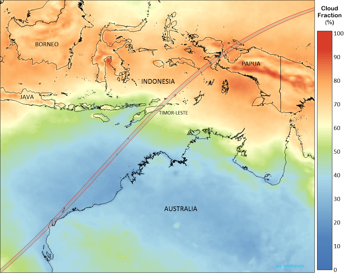
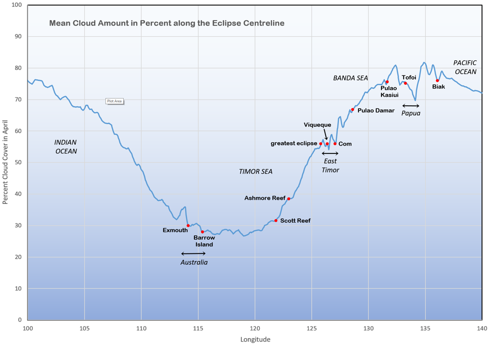
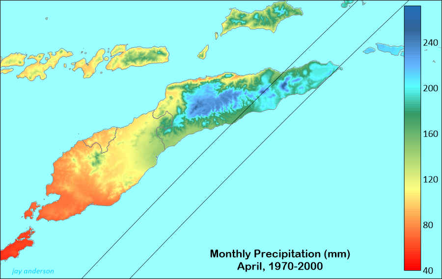
Figure 3 shows the mean April cloud cover as measured by a suite of polar-orbiting satellites in the years from 1995 to 2015. This information is reproduced in Figure 4, which shows the satellite-measured cloud amount along the centre line. The lowest cloud amounts are found along the Australian portion of the eclipse track and over the southern part of the Timor Sea. Mean cloud amounts in this region range between 25 and 40 percent.
Before the track reaches the point of maximum duration, cloud cover climbs steadily, reaching nearly 60 percent over East Timor. Further along, over the warm waters of the Banda Sea, monthly average cloud cover continues to rise, reaching above 80 percent over Papua and surrounding regions before declining gently over Pacific waters.
Australia
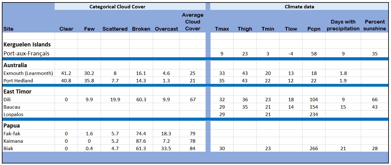
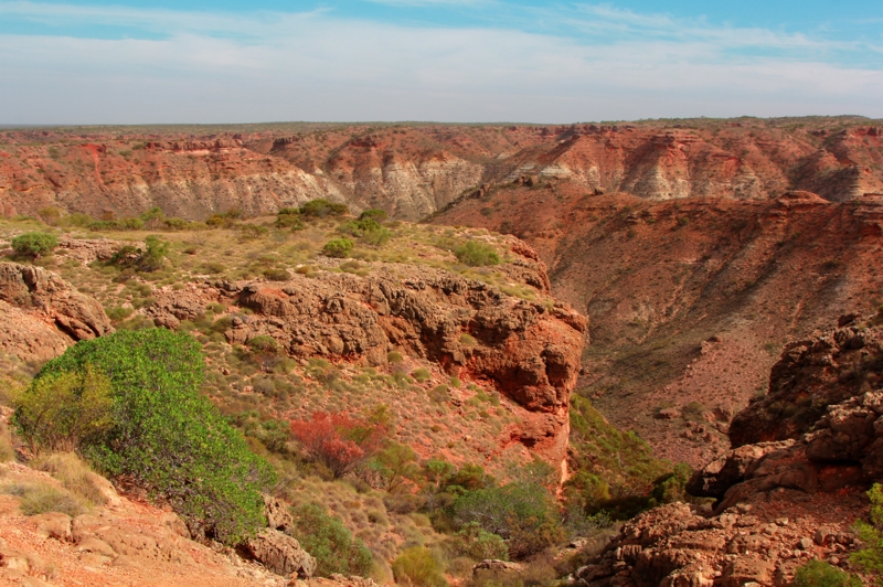
For this (and all) hybrid eclipse, the umbral shadow has a very narrow track. Australia, with the best land-based weather prospects, samples the event for a meagre distance of 65 km across a track width of barely 40 km. Still, it’s a solid hit, with both north and south limits observable from Northwest Cape in Western Australia. As topography goes, the landscape on the Cape is pretty low, around 300 m at best, but it is very rugged with spectacular canyons and gorges cutting though the hills that form the backbone of the cape (Figure 5). The sparse desert-like vegetation will immediately confirm the region’s arid nature and its generous sunshine.
The eclipse comes in the midst of the summer and autumn wet season, but April is a bit of an anomaly, being a drier month in the midst of the wet. Average rainfall at Exmouth, the only community on the Cape, is about 18 mm, less than half that of March and May. It seems almost absurd to denote an 18 mm rainfall as a “wet” season, but it’s considerably higher than the dry spring and summer months of September through December. Temperatures are comfortable for the season, with highs in the lower 30s and lows around 20 (Table 1). At its hottest, temperatures can reach into the low 40s; they have been climbing across Australia in recent years because of global warming.
In the 30 years between 1991 and 2020, climate statistics taken from observations at Learmonth Airport set the number of cloudy days in the month at 6.5 and the number of clear days at 14.6, with the rest lying somewhere in between. A clear day is defined as one in which the average of the 9 am and 3 pm cloud cover is 25 percent or less; a cloudy day has an average of 75 percent cloud cover at the two times. When all of the days of the month are lumped together, the average cloudiness at Exmouth is just over 40 percent at both 10 am and 3 pm, which fits comfortably with the 30 to 36 percent in the satellite record (Figure 4). The number of cloudy days makes April the cloudiest month of the year for Learmonth, but only two days of the month has rain on average.

Cloud cover on the Northwest Cape comes from a variety of weather systems. Some are generated by passing, tropical low-pressure systems that spread cloud across a 600-1000 km-wide area and likely bring most of the April rain. Though intense tropical lows are rare events, one in April, 2014, flooded Exmouth with almost 200 mm of rain. Weak pre-frontal troughs (associated with cold fronts and upper disturbances) often reach northward from more southerly disturbances to touch the Exmouth area, bringing broken mid- and high-level cloud that might require a quick diversion at eclipse time. These northwest-southeast cloud bands are a common feature of Australian weather, but usually peter out and become more ragged in the more tropical latitudes of Exmouth.
On unstable days, cumulus clouds are not uncommon, especially on the higher terrain, though deep convection is rare and so convective buildups would be expected to disappear with the onset of eclipse cooling.
In spite of the menu of possible cloud disturbances, the overriding character of the Exmouth area is its sunshine. Though it’s not a comprehensive survey, examination of satellite images from 2000 to 2020 show clear skies over the Cape on eclipse day on 15 of the 21 years. Two days had small cumulus clouds and another two were plagued with transparent cirrus Only two years had clouds heavy enough to block the eclipsed Sun. Even these last two did not affect the whole of the Cape and movement to a different site would have allowed the eclipse to be seen. It is uncommon to see the whole of the Cape covered in extensive, opaque cloud at this time of year.
Satellite observations of cloud cover are backed up by observations from the ground at Learmonth Airport, as seen in Table 1. Seventy-two percent of hourly cloud observations are categorized as clear or “few” (one-quarter or less sky cover). Only four percent are overcast; the average cloud amount across all of the categories is 25 percent. The satellite record has a greater average cloud amount than the surface observations, likely because the sample area of the spacecraft pixel is around 25 km on a side.
The hilly backbone of the Northwest Cape (the Cape Range) seems to have little influence in making or breaking clouds, in part because of its low elevations and in part by the low humidity of the region. On several days of the month, cumulus clouds will form on the hills, and on particularly unsettled days, on the lower elevations, sometimes along a sea breeze. a feature that is reflected in the small bump in cloudiness at Exmouth in Figure 4. The hills influence the wind direction, though only modestly, turning winds to the south or north to follow the trend of the topography.
Exmouth and area
At the best of times, in a non-eclipse season, Exmouth is a difficult place to find accommodation without a reservation. Its population of 2,500 triples or quadruples in the tourist season. Hotel rooms are limited and the caravan parks fill up quickly. Several operations offer beach camping, some of it quite luxurious, but it is difficult to imagine enough space for the thousands who are likely to travel, even though it is remote, even by Australian standards. Nevertheless, Australia is probably up to the challenge and Exmouth is already deep into planning for as many as 50,000 visitors.
This very narrow eclipse track cuts across the North West Cape at a steep angle, which, because of the layout of the road network, makes reaching the track much more of a drive than it might otherwise be . This is a remote part of Australia and the only convenient access is along the paved, one-lane-each-way North West Coast Highway (aka Minilya-Exmouth Road). The highway turns north to Exmouth at Minilya where the colourful Minilya Bridge Roadhouse can provide gasoline and food, but little more. From there, it’s 164 km to the south limit of the eclipse track and 225 km to Exmouth.
Exmouth’s closest substantial neighbour is Carnarvon, 365 km to the south and 300 km short of the eclipse track. The route northward traverses a sandy, brick-red, scrub bushland that is almost completely devoid of human presence over very long stretches of highway. Every traveller must keep in mind the distance to the nearest petrol station and the quantity of gasoline in the tank.
Between Milinya and Exmouth is a turnoff (Maud’s Landing Road) that leads 12 km to Coral Bay, a sea-side tourist oasis and “marine paradise” that sports a small amount of accommodation that stretches across the price spectrum. Coral Bay is just as popular as Exmouth for those wanting a visit to the Ningaloo Coast, but with a population of barely over 200, cannot handle a large influx of visitors. While a few lucky eclipse travellers might find a landing spot at Coral Bay, it’s still another 90 km to the track and 150 to Exmouth.
The Milinya-Exmouth Road is the only hard-surface road into the eclipse track, but there are numerous side roads—”road” is a bit complimentary, since they are tracks in the sand—that lead to mysterious destinations to the east and west. These tracks are not for the faint of heart: they likely require some navigational skills, a decent map, a GPS, and a four-wheel-drive vehicle. The best of these tracks is Ningaloo Road, which heads west toward the Indian Ocean coast about 40 km north from the Coral Bay junction. Ningaloo Road reaches the south boundary of the eclipse path after a distance of about 22 km. It’s the shortest route to the eclipse track, but probably not the quickest. When it reaches the coast and turns north toward Exmouth, it changes its name to Yardie Creek Road. The road is paved after its namesake, Yardie Creek, is crossed, about 44 km farther along. There seems to be a large amount of informal camping along the coast, but closer to Exmouth, at Yardie Creek, there are formal accommodations. To get there, you’ll first have to ford that creek!
For the most part, overnight parking is not permitted along the highways, but beaches are pretty much fair game if it’s just for the night. Enforcement seems casual; we parked beside the “no overnight stopping” sign outside Exmouth and no one bothered us or the other 30 sleepers! Exmouth was completely filled by travellers at the time (in mid-May) and the roadside was the only possible alternative. We were lucky, for free-range camping (or wild camping) is prohibited in Australia and you can be fined.
Truck rest stops are fair game for overnighting however, as well as free camp sites that may be advertised. There are a few pull-offs on the way to Exmouth, though they are just a widening of the sand margin along the highway. Some of the many tracks that lead to the side of the highway might look enticing and convenient, but you are on your own about permissions if you make use of them.
Accommodation in and around Exmouth and Coral Bay is probably spoken for, and so you might be tempted to travel overnight to reach the eclipse track. If you travel between Coral Bay and Exmouth in the dark (I’ve done it), you will hit a kangaroo, or several, unless you keep speeds well down and maintain a sharp lookout. Sheep eyes shine brightly in headlights, but kangaroo’s do not and they’re dark brown to boot. If you travel through cattle country (Exmouth is not), you will likely be moving through unfenced range. If you need reinforcement about using daytime travel only, just take note of the number of dead cows along the highway.
One prominent international rental agency forbids driving:
- at night, beyond 100 kilometres of the Perth city limits between dusk and dawn or outside any town or city limits between dusk and dawn in Western Australia
Similarly, you may only drive:
- in Western Australia, only on graded, unsealed roads where you have authorisation from the company in writing;
- in Western Australia, you must not use the vehicle off road (e.g. on a fire trail, beach, track, grassed area or to cross streams or any other body of water) unless you have authorisation from the company in writing
Rules are a little less rigorous for 4-wheel-drive vehicles, but in my experience, travel off of paved roads often requires a phone call to the company for permission. Read the agreement!
On the highway opposite Learmonth Airport lies the Learmonth Solar Observatory. It’s an impressive array of antennas from the highway, but the site is restricted and visitors are not permitted. The observatory is part of the GONG network (Global Oscillation Network Group) and also one of the sites that contributes to the solar weather forecasts used to monitor the solar wind and flares. In 2023, the observatory and its staff will likely be fully occupied with science observations.

Outside Exmouth, to the south, the Cape Range offers spectacular gorges and canyons that can be approached by rough roads leading west off of the Milinya-Exmouth Road. These will be attractive spots to view the eclipse, but once again, the rough road and sparse parking will limit the number of visitors that can be accommodated. The highway north out of Exmouth reaches the top of Northwest Cape and then turns southward along the Indian Ocean side of the cape to become the Yardie Creek Road, allowing you to view the eclipse from the Indian Ocean coast by travelling from the north or south.
From Exmouth, Yardie Creek Road is narrow and paved as far as Yardie Creek. Along the way, it passes the Milyering Discovery Centre, the reception centre for the Cape Range National Park and the Ningaloo Marine Park. The whole of Yardie Creek Road seems to be lined with entrancing beaches and there are numerous approaches to the oceanfront from the highway. At Yardie Creek itself, the paved road comes to an end, but if the creek is not flowing, it is possible to continue southward on dirt and sand tracks that eventually turn into a graded road on the way to Coral Bay or to Ningaloo Road where you can go east to the Minilya-Exmouth Road. You will need four-wheel drive, a knowledge of the tide (to cross the creek) and a spirit of adventure. You’ll be in the eclipse path for about 50 km beyond Yardie Creek.
The Timor Sea
The good weather prospects over Australia extend across the southern and central parts of the Timor Sea, making ship-based observations an attractive option. Since the Exmouth area has a very limited tourist infrastructure, a ship may be the only choice if good-weather prospects are important.
The cloud statistics from Figure 3 and Figure 4 give the Timor Sea an April cloud percentage that is comparable to the Northwest Cape, at least as far as Scott Reef. The weather on the Sea is entirely tropical in character, with a high frequency of small convective clouds, thin cirrus, and occasional extensive cloud shields generated by passing tropical depressions. Cloud cover increases northeastward along the track, mostly due to an increasing frequency of tropical depressions that form in the monsoon trough associated with the ITCZ, though the depressions can link up with pre-frontal troughs stretching to the southeast across the continent.
Ocean observations benefit from the mobility of a ship, provided the appropriate direction of movement can be correctly anticipated. This is not always easy from shipboard, as the motion of the ship confuses the true direction of cloud movement. Animated satellite observations should be able to provide that information.
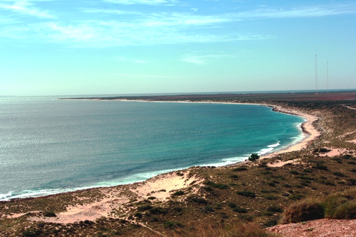
Timor-Leste
Timor-Leste is a mountainous country with peaks that reach above 2300 m beneath the eclipse track. While satellite observations show that the higher elevations build a heavier cloud cover, it’s a relatively small effect because the climate is already humid and unstable, ready to form clouds nearly every day. In Figure 4, we see that the average cloud cover rises only about 5 percent as the centreline crosses the island.
Day-by-day satellite images show that the cloud cover meanders back and forth between overcast skies and scattered cloud. Eighteen years of satellite images for eclipse day show that seven were completely overcast along the track, five had scattered cumulus clouds but were otherwise clear, and the rest had a mixture of cloud and sunshine that would make luck a large part of a successful view of the event. For the six days of mixed cloudiness, locations along the coast were often rewarded with clear skies when winds blew inland from the ocean.
While the relationship between cloud and precipitation is somewhat fuzzy, the precipitation chart in Figure 10 suggests that the north coast has a higher frequency of clear skies than the south. This may be due to the roughness of the south coast compared to a broader coastal plain in the north. Google Earth also suggests that travel by road is easier in the less-rugged north.
Papua
Where observations from Timor-Leste suggest that a view of the eclipse will be a bit of a challenge, statistics from Papua are downright discouraging. The graph in Figure 4 shows cloud averages in the range of 70 to 80 percent. Cloud amounts actually decline over land, a reversal of the usual trend. The path across the island follows the lower elevations of the “neck” of the dragon, but the minimum of cloud cover comes on the east side of the high terrain that forms the thin “throat” of the Papua landform. It is a moot point whether terrain is responsible for this decline.
Satellite images for eclipse day over the past 20 years go agree with the general pattern shown in the monthly statistics. The cloud cover is seldom overwhelming, but instead is infused with numerous holes that let the sunshine through, heating the ground and promoting the growth of cumulus clouds. Eclipse observations would be a challenge, but what an adventure!
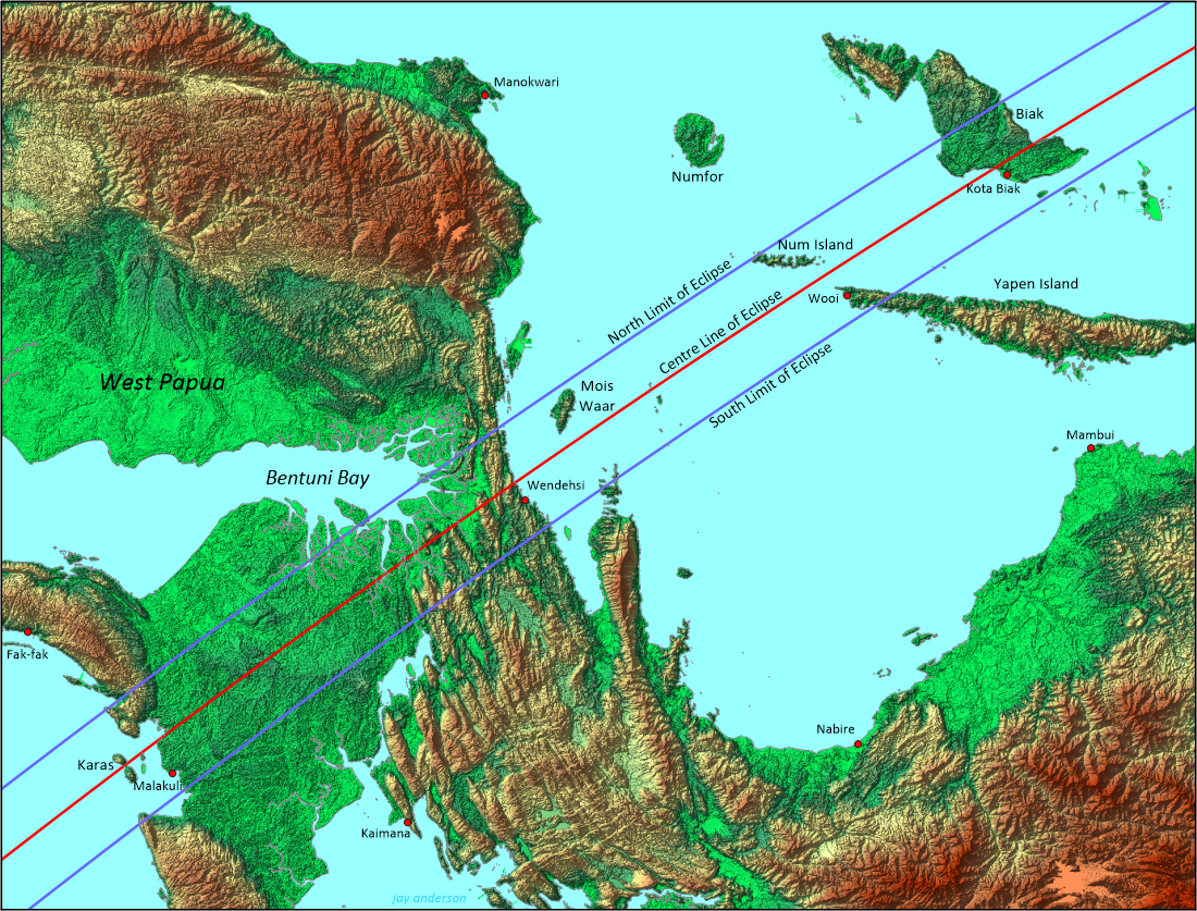
Whatever the characteristics of the cloud cover, travel to the eclipse in Papua will require considerable planning. Population is sparse and villages are widely separated. Access for much of the eclipse track may have to be by boat. Perhaps the most convenient point to access the eclipse is to fly to Babo, which lies a little over 7 km from the north limit. From there, it may be possible to hire a boat to reach the Moon’s shadow. Babo can also be reached by ferry from several locations in Indonesia.
Tropical Storms
Tropical cyclones (called hurricanes, tropical storms and tropical depressions in the Atlantic) are a prominent part of the climatology of Australia and Indonesia. In Australian waters, the storm season lasts from December to April, but the fact that April is at the end of the season does not mean that storms are uncommon. Long-term records show an annual average of about four tropical storms in ten years at Exmouth and one per year in the Timor Sea. La Niña years bring more storms; El Niño, fewer. Over Northwestern Australia, April is not the month with the greatest number of tropical storms, but it is the month with the greatest number of Category 4 and 5 storms, the strongest of the lot. In March, 2014, Olwyn, a Category 3 cyclone, dropped 114 mm of rain on Exmouth.
Figure 12 shows the tracks of April tropical systems from 1950 to 2014. Several characteristics are evident from this chart:
- storms favour the Timor Sea
- there are no storms in a narrow band along the equator
- Exmouth is outside the main storm area, and only affected by about a half-dozen April storms in the 65 years
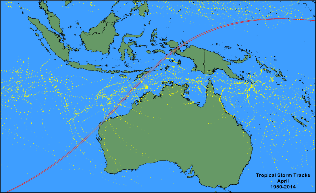
Tropical storms have a dimension of around 700-1000 km at maturity, mainly because of the large cloud shields that they throw up. For this eclipse, they are most likely to present a problem for ship-based observers, who might be forced to deviate from the shadow track in order to avoid the winds and weather. Fortunately, the risks are small and forecasts sufficiently accurate to provide plenty of warning and offer alternative siting.
With the expectation that COVID-19 will be tamed, this eclipse will bring a welcome return to normalcy for eclipse watchers. Good luck with your travels.
Updated July 2021.