Total Solar Eclipse
2027 August 2
 Overview
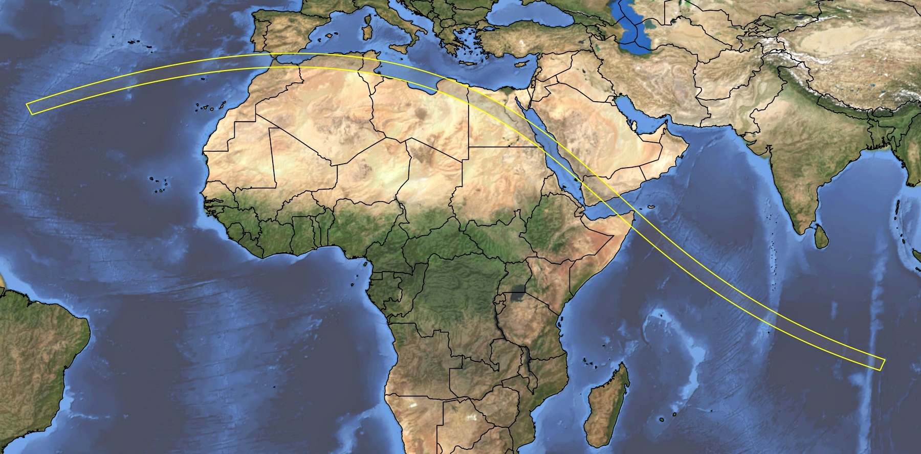
The 2027 lunar shadow first embraces the Earth over the sub-tropical mid Atlantic in a region of moderately cloudy skies well to the north of the hurricane-breeding zone off western Africa. The umbral path misses the islands of Porto Santo and Madeira by a meagre 70 km on its eastward trek, choosing instead to make landfall in Spain and Morocco six minutes later. For the next 4,000 km, it first skips along the Mediterranean shore before gradually turning to a southeast heading. The turn to more southerly latitudes comes with increasing amounts of cloud, but, except in the mountains of Arabia, most of that intrudes after the path heads out across the Indian Ocean, toward its ending near the remote atoll of Diego Garcia.
Few eclipses come with a guarantee of cloud-free skies, but, in parts, the path of the 2027 total across North Africa comes very close. Figure 1, composed from measurements taken by several satellites in the course of the day, shows a broad area of blue tones along the track, particularly over Egypt and Libya. Because this is an average for the whole day, differences between morning and afternoon are lost; but farther along, we will take a look at cloudiness a little closer to eclipse time. In Figure 1, there are a few weather challenges in Morocco, Algeria, and Tunisia, but because the larger part of the eclipse track skirts the north side of the Sahara Desert, the climatology farther along the shadow path borrows its character from that great sand sea. It’s hot, it’s dry, it’s sunny, and it’s dusty.
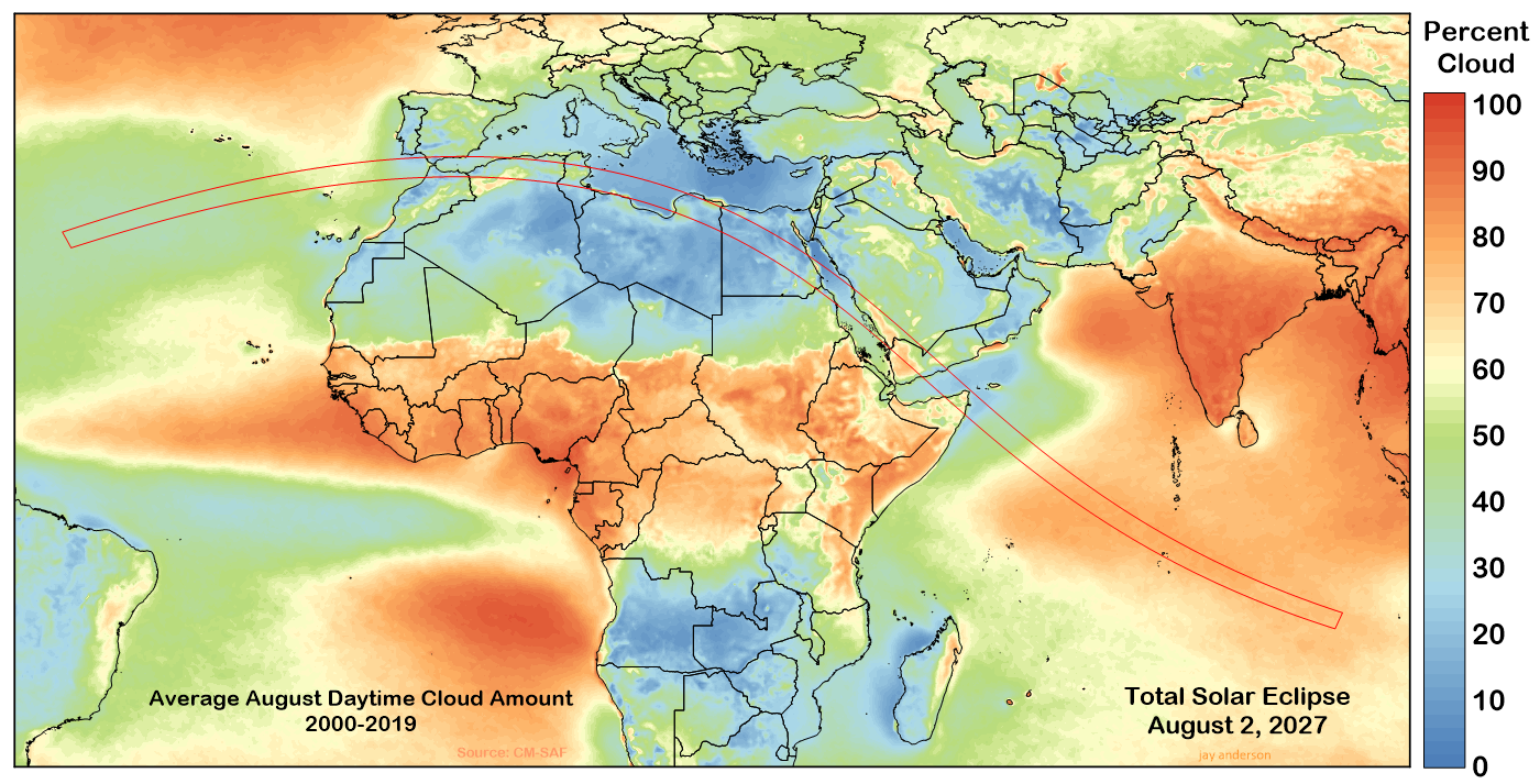
An eclipse thrives on that kind of climatology. Some parts of the eclipse track—over Libya and western Egypt—have seen no August cloud on eclipse day whatsoever in the past 23 years. And even though Spain and Northwest Africa have their cloudy days, it’s not common and eclipse-day chances are still very good.
Most of this good weather comes courtesy of the Azores (or Bermuda) High that lies in the mid-Atlantic west of the Straits of Gibraltar in mid-summer. The High extends a pressure ridge across northern Spain with an extension southward into the central Mediterranean near Tunisia. A stationary heat low takes up a summer home every year in northern Mali, near the Algerian border while a second (and much stronger) heat low can be found further along the track, over the Arabian Desert. Both of these affect the wind flow and the generation of dust storms, but have little influence on cloudiness.
From Morocco to Tunisia, cloudy disturbances largely follow the wind. The high-level subtropical jet typically lies over Northern Spain in mid-summer and disturbances along this flow only rarely reach the African part of the eclipse track. These are systems that bring large shields of cloud, smothering the eclipse track and all but ending any chances of a view of the Sun. Fortunately, they are uncommon in August and only affect the western part of the path.
A small tributary jet stream comes out of the southwest, flowing over Morocco and Algeria and carrying disturbances up from equatorial regions that trigger the formation of cloud and thundershowers when they reach the Atlas Mountains (Figure 5). Thunderstorms require heat, and so most buildups come in the afternoon, after the lunar shadow has passed. Their influence on eclipse visibility is subdued, as they are usually composed of patchy mid-level cloud in the early morning.
There are other minor weather systems that can have an impact on eclipse viewing, but with a more regional impact. One of these is the Atlas Low, which forms south of the Atlas Mountains in northeast Algeria and moves eastward. It is not a cloud producer, but can generate widespread dust storms. Infrequently, small lows can form off of the Atlantic coast of Morocco and the Mediterranean coast of Algeria, but their cloud shield is usually limited to regions near the shore.
Over Libya and Egypt, cloud is almost unknown in the summer months and it’s not until the track reaches Luxor that the cloud fraction begins to climb above zero. After the shadow leaves the African continent for the Arabian Peninsula, sunshine prospects begin to weaken, but even here there are clear-sky refuges that will tempt the most fastidious eclipse chaser, particularly along the Red Sea coast.
Morocco, Spain, Gibraltar, Algeria, and Tunisia
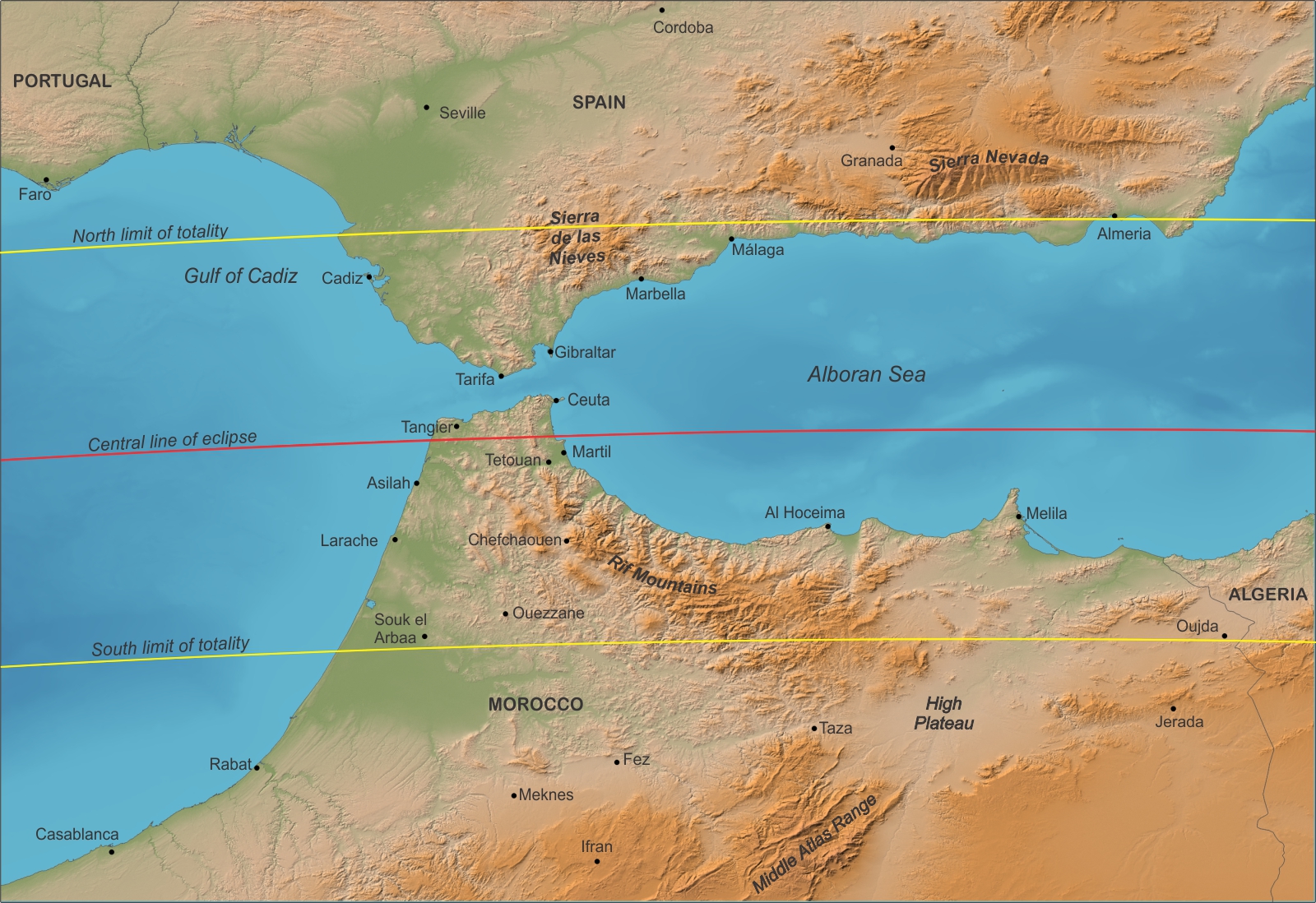
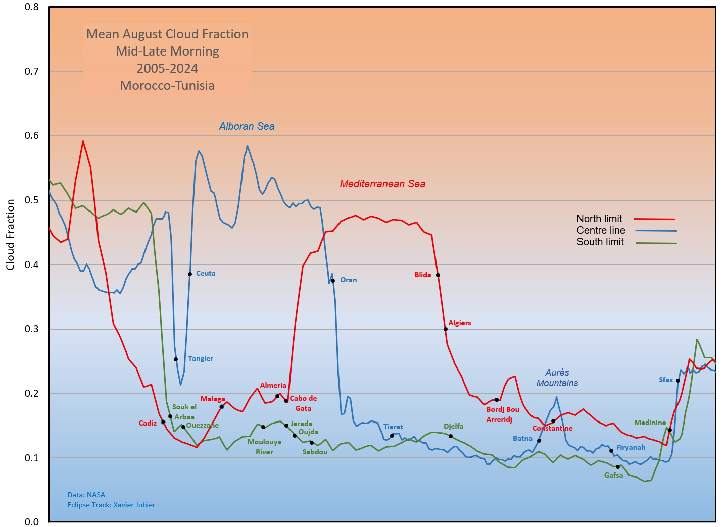
Figure 3 shows a zoomed-in map of the mean morning cloudiness over the western Africa eclipse track. Its corresponding graph in Figure 4 traces out the cloud fraction (i.e., percent cloud if multiplied by 100) along the centreline and the north and south limits. The data are pretty encouraging. Cloud cover seems highest over water, even though there appears to be a large contribution from sun glint in the satellite measurements. Cloudiness is lowest where the Sahara Desert has its biggest impact, near the south limit over Tunisia. High terrain (Figure 2) has a minor influence: it sometimes wears a cloudy cap in the morning, but it’s very subdued until the daytime temperatures climb and convection starts. In the morning hours, average cloud amounts rise only about 4 percent between the Moulouya River and Oudja as the south limit crosses the Rif Mountains; on the centreline, there is an 8 percent rise across the Aures Mountains in eastern Algeria.
Because these graphs are derived from mid-to-late morning satellite passes, they come after the shadow will pass and so fail to capture the influence of some early morning cloudiness that haunts coastal regions before first contact. The next few sections will deal with that cloud.
In detail: Morocco west of the Atlas Mountains
Ocean temperatures play a major role in forming cloud along the Atlantic coast of Morocco and Spain. The cool Canary Current saturates the overlying air, forming a patchy low-level cloudiness and coastal fog that creeps inland at night. At the same time, cool overnight temperatures saturate the low-lying air over the land, giving rise to fog banks that may form in small patches or in extensive shields that cover large parts of the landscape, often lifting toward morning to turn into a layer of stratus clouds. Though the marine stratus typically moves only a short distance onto the coast, it occasionally merges with the land-formed stratus and goes on to form large sheets of shallow cloud that can cover the southern half of eclipse track for 100 km inland. This is most likely to occur near coastal towns of Asilah, Larache, and Souk el Arbaa where the terrain rises slowly from the coast (Figure 2). At times, the stratus blankets the landscape almost as far as Ouazzane at the foot of the Atlas Mountains.

Tangier is not immune from the marine cloud, but because the city is tucked a small distance into the Straits of Gibraltar, the stratus tends to stay on the western side of the Tangier Peninsula where a 300-m rise in the land (Cape Spartel) hampers its intrusion into the city. It’s not complete protection, as the stratus cloud has a depth of about a kilometre and can sneak around the coast into the Strait. On rare occasions, stratus that piles up on the east side of the Tangier Peninsula near Ceuta makes its way around the 1,000-metre Rif Mountains that separate the two cities, but this is very unusual. In spite of the mountain barriers, there is often a misty character to Tangier’s sunrise and rarely, a nasty cloud cover that won’t go away in time for an eclipse.

On eclipse day, the biggest uncertainty may be “how quickly will the stratus will burn off after sunrise,” as the eclipse reaches maximum at about 9:44 am local time. For Tangier, the answer is “very likely,” but for other sites along the coasts, it’s not at all certain. An observing site on the western beaches of Morocco, at Asilah or Larache, may find that the marine cloud lingers past totality (Figure 5), as the cool ocean nearby makes the Sun’s heating less effective. Farther inland, the fog/stratus dissipates more quickly and is likely gone before second contact. A short move inland will often settle the problem unless the low cloud is particularly wide spread.
Another complication is whether the cooling associated with the eclipse will cause the fog to reform. It did so along the Baja coast in 1991, and I’d guess the answer here is also “yes” if the cloud hasn’t dissipated before the mid-way point between first and second contact.
To get a better answer to this problem, I’ve examined geostationary satellite images from 2024 and 2025 for several viewing sites along the eclipse track from Tangier to Sfax and selected days in which the eclipse would have been visible (Figure 6). The data were collected for dates between July 12 and August 18 in both years, as close to 2nd contact as the images permitted. The resolution of the satellite images is about 1 km and did not always give me a conclusive answer about whether the eclipse would be visible, usually because the cloud was patchy or semi-transparent. In some cases, I examined webcams from the sites for a better idea of eclipse-time cloud cover.
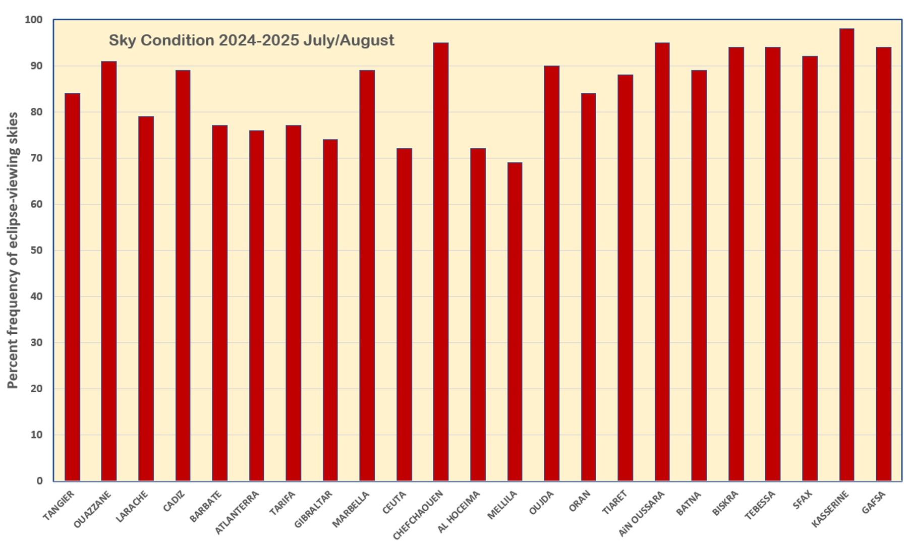
At sites that fared poorly, marine stratus was often the problem. In Tangier, eclipse-viewing sites that lie in the central or east side of the city are most likely to avoid a lingering morning mistiness. In particular, the beaches along the Bay of Tangier are very attractive as a viewing site. If you want to observe from the south limit in Morocco, it’s probably a good idea to go at least 70 km inland, toward Ouezzane, as the flat terrain in around Souk al Arbaa (Figure 2) is a gateway for marine cloud.
In detail: Spain from Cadiz to Tarifa
The Atlantic coast of Spain is visited by the same marine cloud that affects Atlantic Morocco. The pattern is similar: a threat of morning cloud and fog on the coast, but generally clear skies inland. The Atlantic Ocean cloudiness usually doesn’t penetrate into the Strait of Gibraltar past Tarifa, so Marbella and other sites along the Alboran coast fare particularly well.
Cadiz, near the north limit, has a lower frequency of marine cloudiness (but more high-altitude cloud) than Spanish sites farther south, such as Barbera, Atlanterra, and Tarifa. The city had an 88 percent frequency of sun-visible days in the survey, while the other three sites averaged a less promising 74 percent. The best advise that can be offered on this coast is to go inland since ocean cloud is blocked by the rugged terrain along the shoreline. According to the satellites, inland Spanish sites are excellent eclipse havens with average cloud amounts that drop below 15 percent.
In detail: Gibraltar
Gibraltar is a special case. The tiny peninsula sports a steep 300-400-m escarpment that faces the sunrise horizon and a gentler slope that falls away to sea level on the west. The terrain flattens toward the south tip (Europa Point), providing a clear view to the rising Sun on eclipse day. The terrain is a mixed blessing – it intercepts an easterly flow and allows any marine cloud to pack up against the coast, but also provides wide-ranging vistas for an eclipse party.
Wind is an important component of the weather in the Strait, almost exclusively blowing from either the east (Levanter) or the west (Poniente) across the Alboran Sea. The Levanter (Levante in Spanish) tends to be the more persistent, sometimes blowing steadily for days and even weeks, particularly in the summer months. The two winds make the Strait and the Gulf of Cadiz prime spots for kite boarding and wind surfing.
Figure 3 shows that the waters of the Alboran Sea and the Strait of Gibraltar are cloudier than any other region along the western track. Fed by inflowing Atlantic currents, the cool surface waters of the Alboran Sea create a stable, surface-based temperature inversion. Air beneath the inversion often (but not always) turns to fog, stratus, and haze as it is cooled from below. This ground-level cloud is thickest in the morning and evening, but it’s usually only about a kilometre deep and has trouble moving inland against a rocky coast. It’s also quick to burn off in the morning sunshine. Morning fog gives Gibraltar sunrises a misty character and they are often semi-transparent once the Sun has had an hour or two to work on them, though parts may persist in some form through the eclipse.
Webcams in Gibraltar reveal that the stratus cloud that impacts the peninsula is usually patchy and a hypothetical eclipse watcher could often find a clearer patch to watch the Sun somewhere nearby or accept a less-than-perfect view. Data in Figure 5 gave Gibraltar a 74 percent chance of a sunny view, but this is too pessimistic for a mobile observer, as it reflects only the presence of cloud somewhere against the peninsula and not necessarily the whole of it. The resolution of the satellite images is too low to pinpoint just where the cloud lies on the peninsula, particularly as its location is variable from day to day, but it’s probably fair to say that the flatter southern suburbs are more likely to see the eclipse.
The Levanter is also responsible for a streaming flag of cloudiness that frequently flies from the upper slopes of the 426-m Rock of Gibraltar when the wind blows between 15 and 40 km/h. The size and persistence of this iconic banner depends on the strength of the wind, the amount and depth of the moisture, and the stability of the air and can take on many engaging forms, all hanging unmoving from the peak. Because the banner is stationary, it is easily avoided, as it lies on the north side of the Territory, next to the airport.
Eclipse photographers looking for an image that includes the banner should pay close attention to the wind forecast and position themselves off to the side of the peak with a view of the Sun. The eclipse lies in an easterly direction (095°) at relatively low altitude (38°) from Gibraltar. The banner cloud is most visible from the airport with its restricted access and will be difficult to frame in an eclipse picture from any other land-based site. A composition from the water might work.
The Poniente, is a dry westerly or northwesterly wind that brings good visibility in the summer months—enough to see the coast of Africa from Tarifa. It’s not as frequent as the Levanter and generally a bit weaker. Outside the Strait, at Cádiz, the Poniente is a cool and humid flow that moderates the high temperatures of summer.
Sunshine statistics for sites in Spain and Morocco are less favourable than the satellite observations would suggest, but these incorporate afternoon hours when clouds are usually more extensive. The small amount of rain in the records probably reflects the impact of cold fronts that reach the track. In Oudja, it’s probably due to thundershowers in the Atlas Mountains.
In detail: The Alboran coast of Morocco
The western end of the Alboran Sea is constrained by the Sierra de las Nieves on the Spanish side and by the Rif Mountains of Morocco on the south, causing winds to be squeezed through the Strait. While the terrain on the Spanish coast has little influence on cloud (except at Gibraltar), that on the Moroccan side is much more imposing.
Easterly flows are concentrated by the shape of the coastline of Morocco, which has a scooped or basin shape (like a baseball mitt), trapping onshore winds (Figure 2). As shown in Figure 5, stratus clouds and the rare weather systems that move over the Alboran Sea pack up against this coast, pressing cloud against the Rif Mountains. The cloud is more persistent than the marine stratus along the Atlantic, because the Rif Mountains also help to lift the air, adding a second mechanism for building cloud. Ceuta is less affected by this trapped cloudiness than sites farther south, between Tetouan and El Jebha; that coast should be avoided on eclipse day. Very occasionally, the cloud along the Ceuta coast is deep enough to cross the 1000-metre Rif Mountains and reach Tangier.
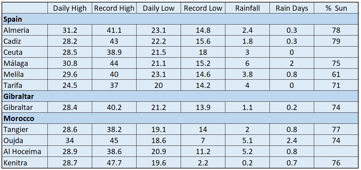
Further along the coast, to Al Hoceima and Melilla, stratus is also a frequent daily visitor, though it burns off a little more readily. Nevertheless, the results in Figure 5 suggests that the Mediterranean coast of Morocco is a dicey place to wait for an eclipse, especially as a small movement inland would bring much better weather. Sunshine measurements at Melilla average only 61 percent of the maximum possible, well below the 75 to 80 percent at many other locations along the track.
Algeria, and Tunisia
Algeria’s climate is strongly influenced by topography, particularly the Tell Atlas range that runs parallel to the Mediterranean coast (Figure 7). To the south of these coastal mountains lies a dry highland plateau, the Hautes Plaines (High Plateau), ranging in elevation from 400 m in the east to over 1000 m in the west. Still farther inland lies a second parallel chain of mountains, the Saharan Atlas Range, higher than the Tell Atlas and defining the northern boundary of the Sahara Desert. The coastal range creates a rain shadow on its southern side, blocking moisture that would arrive with westerly and northerly winds from moving into the plateau and the Sahara Desert. The Hautes Plaines, while dry enough to be described as a part of the Sahara, are home to numerous salt lakes and salt pans that can act as a source regions for local dust storms. The Sahara Desert itself (the Ergs) is located on the south side of the Saharan Atlas Range and intrudes onto the eclipse track only in southeast Algeria and southern Tunisia.
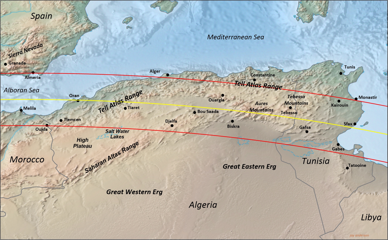
The north limit of the eclipse track generally lies along the coastal plain (Tell) as far as Alger after which it encounters the Tell Atlas Range and then the Tebessa Mountains along the Tunisian border. The centre line samples all of the regions—the Tell, the Tell Atlas Range, the High Plateau (Hautes Plaines) and the Aures Mountains; the south limit traverses the Hautes Plaines and the Sahara Desert into Tunisia. In spite of this rough and varied landscape, morning cloudiness is very subdued and promising eclipse weather can be found at most sites.
The relatively minor impact on cloudiness of these three regions can be teased out of Figures 3 and 4. Most noticeably, it can be seen that the Tell Atlas and the proximity to the Mediterranean gives the north limit a higher average cloudiness than either the high plains or the desert, as might be expected. Another prominent terrain impact can be seen over the Aurès Mountains on the centreline, which are high enough to form their own brand of cloud, though only increasing about 8 percent above the surrounding terrain. These are morning cloud statistics – by afternoon, when the convection begins to build, the eclipse track is much cloudier.

As in Morocco and Spain, wind is a major feature of the North African climate, particularly for its role in bringing dust and sand storms. Prominent among the various types is the sirocco, a south or southeast wind in advance of a low-pressure system coming from the west. As a south wind, it has many aliases along the eclipse track—ghibli, khamsin, harmattan, chibli, haboob, and simoom—though not all are born of the same conditions. In Algeria and Tunisia, the sirocco brings hot and dry weather from the Sahara; after crossing the Mediterranean and reaching Europe, it’s much more humid.
The desert climatology of much of the eclipse track makes for dry summer weather but on some parts of the track, the proximity of the Mediterranean and its ready moisture supply makes for a wetter August than at inland locations. Occasional cold fronts that sweep across the Mediterranean can bring wet days when they run up against the Tell Atlas Range and likely contribute much of the rainfall at Constantine and Alger in Table 2. Days with thunderstorms are frequent over the mountains and are responsible for the small amount of precipitation inland, such as at Djelfa and even Ouargla (though only once every ten years).
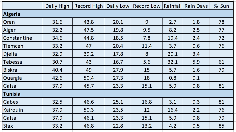
In Tunisia, the whole of the shadow path is over land as it descends from the Tebessa Mountains onto the smoother terrain along the Mediterranean coast. On the centre line, the Aures Mountains in Algeria boost the cloudiness by a few percent but the Tebessa Mountains have almost no cloud-making ability. The north limit, crossing a rougher landscape, has about 10 percent higher cloudiness than the other tracks. Beyond the mountain heights, the cloud amounts drop sharply as the comes into the influences of the Mediterranean coast and the Sahara. This fortunate topography gives Sfax and the region to its south the lowest average cloud amount along the western part of the track.
Dust and sand storms
One cannot have an eclipse along and over the world’s biggest desert without having to contend with dust and sand storms. Figure 9 shows the 10-year mean August Aerosol Optical Depth (AOD) over North Africa, a measure of the extinction of light by dust and haze. Some of this, particularly in Spain, is due to forest fire smoke, but along the eclipse track, it’s largely due to suspended dust. An AOD of 0.4 would correspond to a hazy atmosphere; in the U.S., the average value is between 0.1 and 0.15. A value of 1.0 would obscure the Sun. Along the centreline, the average August AOD just reaches about 0.3 until the track passes Luxor. The lowest values are near Sfax and Tangier.
From the satellite’s perspective, most high-altitude dust plumes are semi-transparent and presumably are the same looking upward. This makes for a dismal but still successful view of the eclipsed sun. To get a really opaque dust storm, with lots of ground-level sand, you have to be close to the source region. Along the track, those sources lie most often on the high plateau of Algeria, between the Tell Atlas Range and the Saharan Atlas Range, and throughout the Sahara Desert. The main threat in Spain and Tangier is a dusty pall over the whole of the sky from dust blown northward from desert basins in Mali and Mauritania.
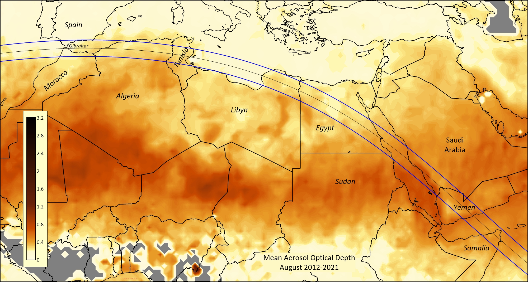
Over Spain and Morocco, the average AOD ranges from 0.12 at the north limit in Spain to between 0.20 and 0.30 in Morocco with the higher values toward the Algeria border. There’s a considerable spread in Algeria, from 0.20 near Oran to 0.41 near the south limit between Biskra and Gafsa. Tunisia as a similar range with the lowest values near Sfax.
Dust is strictly a function of wind speed and direction, and so is possible to forecast. You can obtain 72-hour forecasts of aerosol optical depth and other products from the Barcelona Regional Dust Center or from Meteoblue.com . Among the offerings at the Barcelona Center is one called “Extinction,” which is a measure of horizontal visibility at the surface. This may not be as useful as the AOD, since the eclipse is not being viewed along the ground, but it may give a better impression of the low-level intensity of a dust storm. There are several other products at the Barcelona Center that will allow you to explore the dust threat more fully, but local movement to avoid a mid-atmosphere plume from deep in the Sahara is not likely to be successful, since the dust pall tends to cover a large area.
Libya and Egypt
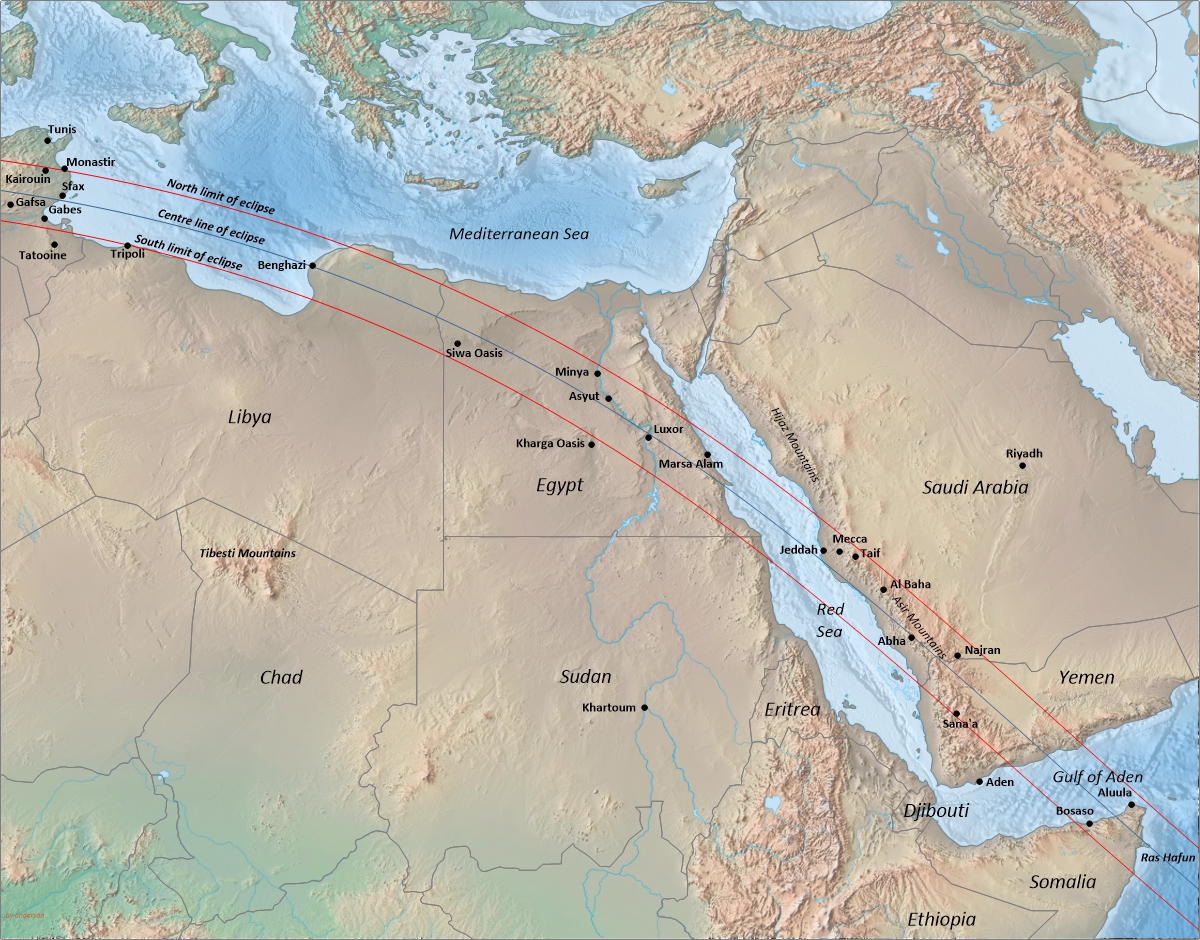
From Benghazi to the Red Sea at Berenice Troglodytica, the eclipse track traverses the Libyan and Egyptian Deserts (Figure 10) during one of the hottest months of the year. It’s a fascinating region with a well-developed tourist infrastructure. For the eclipse chaser, cloud cover—or the absence of cloud— doesn’t get much better.
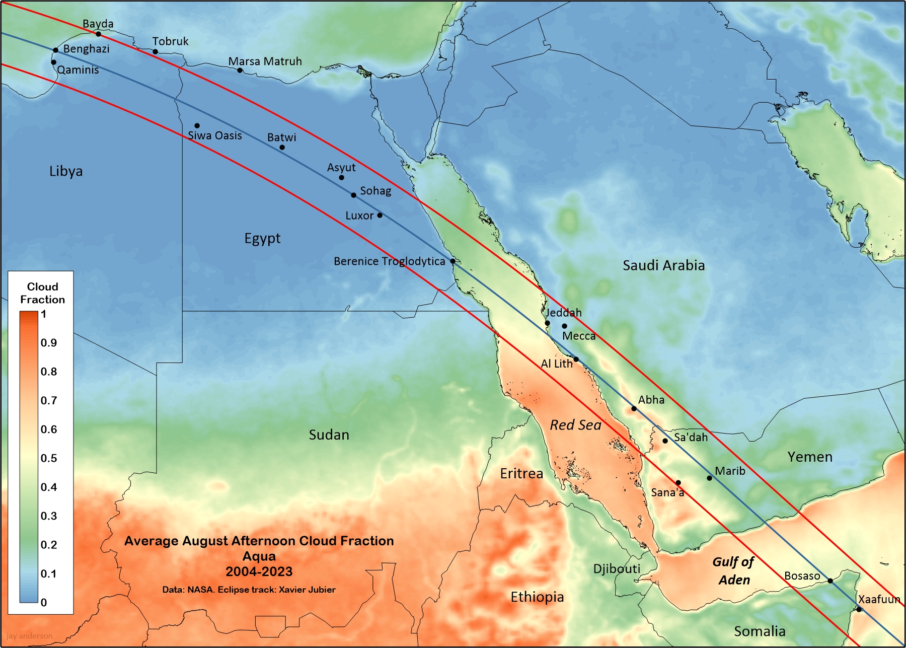
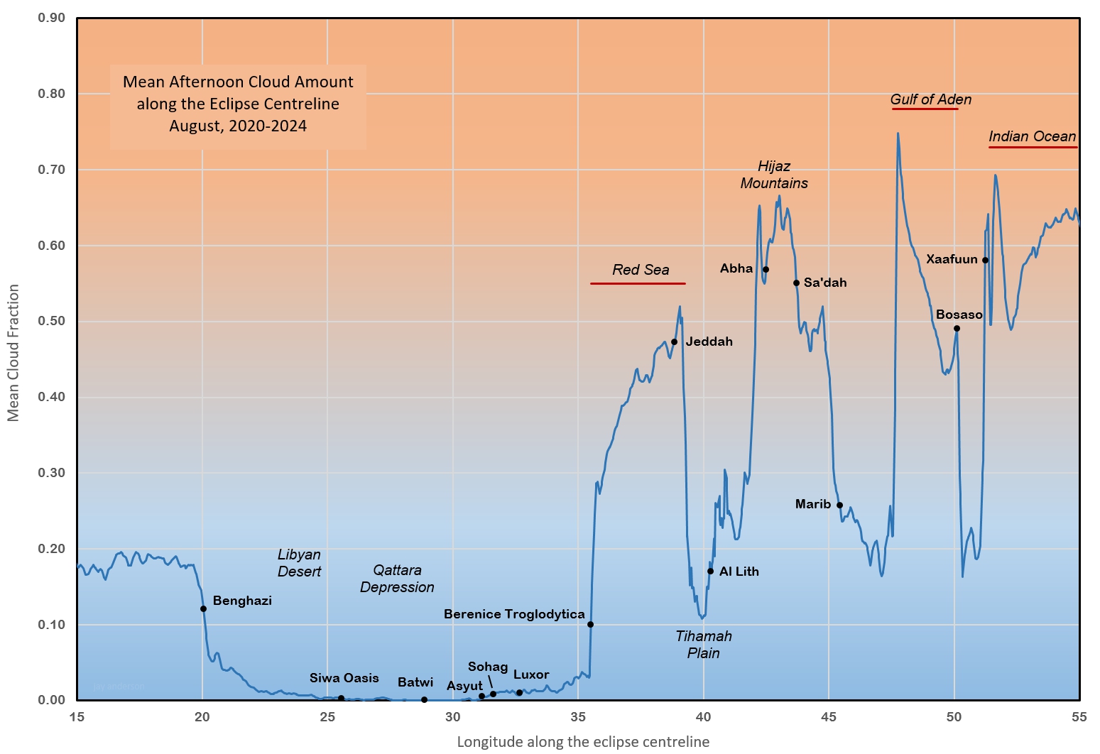
The map of average August cloud cover in Figure 11 and the graph in Figure 12 gives more detail of the satellite-measured cloudiness along the centreline. While it’s not obvious in Figure 12’s graph, the region from Luxor southeastward begins to feel the impact of the eclipse track’s southward turn into more humid climates. At Luxor, the main “threat” comes from transparent cirrus cloud that will mostly affect the images of the deep corona. Very occasionally, there is the buildup of small cumulus clouds here and there, but these should fade away quickly with the large drop in temperature that will come with the approaching shadow.
Shallow morning fog is a frequent nighttime visitor in the area between Marsa Matruh and Siwa Oasis, but this will dissipate long before the eclipse shadow arrives.
Dust is only an occasional problem in Luxor, even though it’s close to where the AOD concentration in Figure 9 begins to climb. Though there were often heavy dust concentrations over southeast Egypt in the satellite images, the storms usually retreated before reaching the city. Given Luxor’s proximity to the Arabian Deserts and to the Sahara, it’s not unusual for even heavy dust storms to come by on occasion, but August seems to be spared the worst of them.
Temperature
Temperature tends to take a back seat to cloud when it comes to evaluating an eclipse site, but in this eclipse, you and your equipment will have to be prepared for afternoon highs that can top the mid-40s and may even reach to 50°C (110 – 120°F) in Egypt. At Luxor, the average high on August 2 over the past 17 years was 42.0°C and there was very little spread from one year to the next. The highest temperature was 46°C.
Modern cameras usually warn of excessive temperatures—usually around 45°C—inside the body and may shut down, especially when shooting video. Canon warns that very high temperatures (and your camera will be warmer than the ambient temperature) may degrade the quality of still images and suggests some ways of mitigating the effect. You can find several discussions of the problem online, but a simple damp white cloth to drape over your camera could be your best friend. Take a look at Tables 1-3 and plan for the expected temperatures. In any event, a sharp drop in temperature will become noticeable about half-way between first and second contact and the problem will likely end.
But don’t forget yourself. Heat stroke is not compatible with solar eclipses. Take the usual precautions, but don’t rely on them. A buddy system with someone to watch you (and you them) may pay dividends.
The Arabian Peninsula and beyond
Beyond Egypt, both cloud and dust begin to increase. Notably, there is over a 40 percent rise in average cloudiness between Berenice Troglodytica and Jeddah, on the opposite sides of the Red Sea. Some of this increase in cloud cover across the Red Sea is probably an artifact of the cloud detection algorithms used to convert radiance measurements to cloud cover since the cloud contours outline the Red Sea so closely, but inspection of the daily satellite images shows that much of it is real. Once the shadow path reaches Saudi Arabia, cloud climbs more quickly (Figures 11, 12), but this is mostly over the Hijaz Mountains. The Tihamah Plain that stretches along the coast does not feel the mountains’ effects and remains sunny with August’s average cloud cover of just over 10 percent. It’s a small area, and so most of the other Saudi and Yemeni sites have sunshine percentages that drop into the 60s. Sunnier skies return as the track leaves the mountains and reaches Marib, where the dryness of the Arabian Desert begins to be felt.
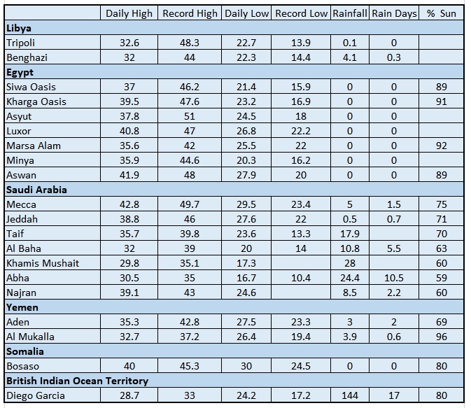
The greatest problem for otherwise suitable sites in Saudi Arabia is dust, as the region is sandwiched between the Arabian Desert on one side and the Sahara on the other. As a result, the Tihamah Plain has by far the highest average AOD along the track in Figure 9. In particular, the regions south of Jeddah stand out with their dusty skies. For the eclipse seeker on the Arabian Peninsula, dust and cloud will both be ongoing concerns.
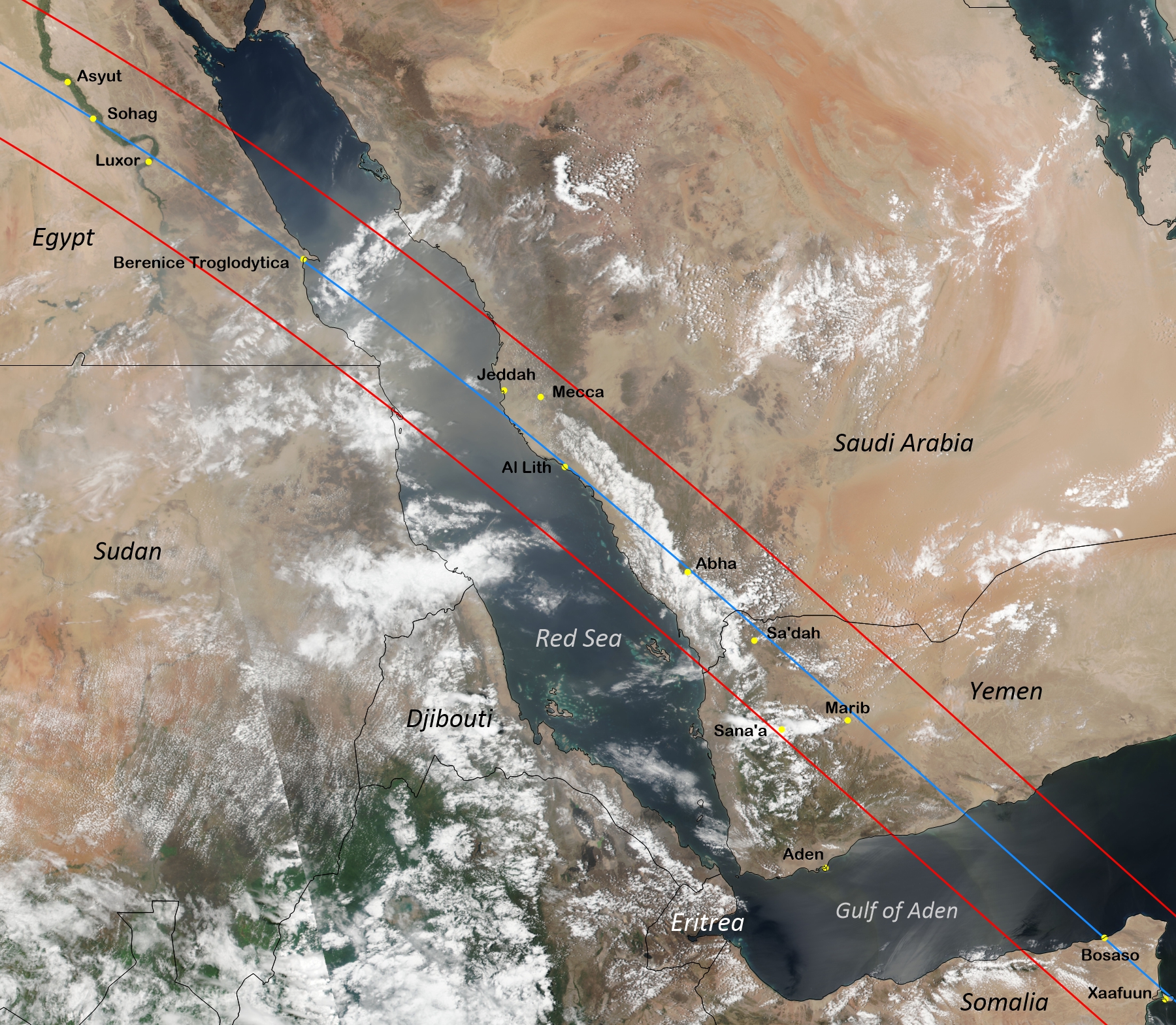
Over Yemen, near Marib, where the eclipse track emerges from the mountain terrain, cloudiness falls to around 20 percent in Figure 12. In Somalia, the interior is protected from the Gulf cloud by the 2,400-m Ogo Mountains. Bosaso, on the coast, has an average August cloudiness of 50 percent, but this drops sharply to under 20 percent on the south side of the mountains where desert conditions prevail. August is the driest month on the Horn of Africa but the Ogo Mountains are high enough to catch a part of the Indian Ocean moisture and the high terrain enjoys a wetter month from a few convective clouds.
The final stop for the lunar shadow is the Chagos Archipelago, a group of seven atolls in the Indian Ocean, that is formally known as the British Indian Ocean Territory. The northern portion of the Archipelago lies under the eclipse track but the only inhabited atoll is the island of Diego Garcia, the site of a joint British-U.S. military base that lies 130 km outside the south limit. It’s treated as a high-security base and access is presently extremely limited in spite of the recent agreement to return the atoll to Mauritius. The average cloud fraction for Diego Garcia is considerably at odds with the claimed 80 percent sunshine but in line with the average monthly precipitation in Table 3.
In retrospect
Cloud cover for this eclipse is among the lowest I’ve analyzed over the last 45 years and it’s easy to lose sight of that when the detailed statistics are inspected up close. Just about anywhere will present a good to excellent opportunity to see this event and bathe in over 6 minutes of totality. Dust is a threat in most areas, but only an occasional serious problem. If you want a guarantee, I’d suggest Siwa Oasis or the Bahariya Oasis (Batwi), both in Egypt, which have almost no prospect of cloud and seem to be relatively immune from dust storms. Benghazi similarly looks like a very good site.
Updated August 2025