Total Solar Eclipse
August 12, 2026
Eclipses come and eclipses go but each one has its own special experience that can later be dredged up from memory, in conversation, or in contemplation. The 2026 total eclipse fits comfortably in that genre, offering an abundance of opportunity, from exotic Arctic icescapes in Greenland, volcanic drama in Iceland, to balmy sub-tropical castles in Spain.
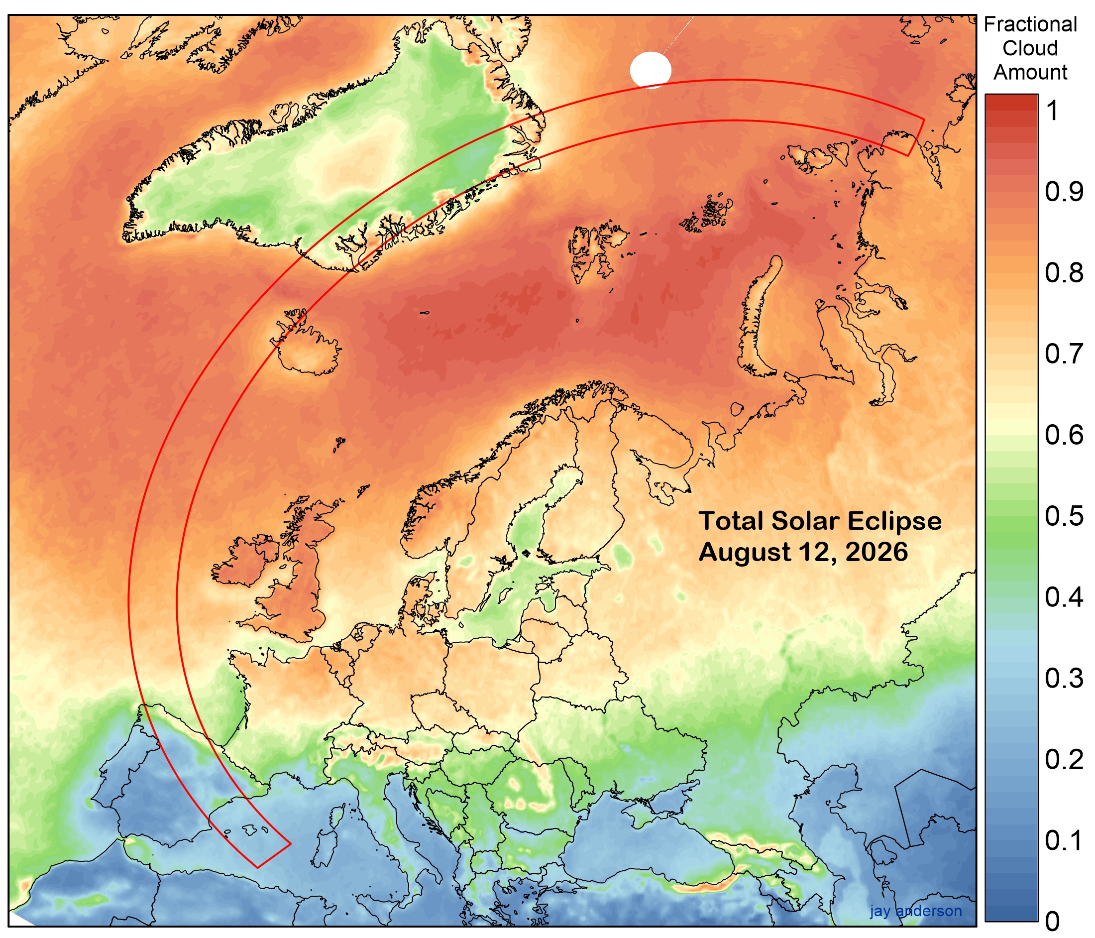
This total eclipse is born and raised in cloud, but happily comes to the end of its hours in a sunny and promising Iberian climate. Two-thirds of the Moon’s shadow path falls over water and even a casual glance at Figure 1 shows that ship-borne viewing sites will be challenged to find good weather. Instead, the best observing sites are on land or close to land and of these, Spain and Mallorca are the most promising.
High-Arctic Weather
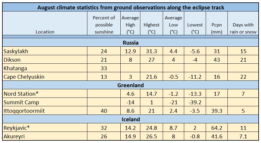
The track of the 2026 total eclipse begins at sunrise over the polar permafrost climate of Russia’s Taymyr Peninsula and the nearby Laptev Sea. The shadow’s touchdown takes place over an uninhabited coast about 125 km north of the abandoned settlement of Nordvik and 250 km north of Yuryung-Khaya, a small Yakut community that is likely the closest inhabited place to the track. According to observations from polar-orbiting satellites, a location along this coast has a mean August cloud amount of around 75 percent. The area is uninhabited and so surface-based weather observations under the shadow path are unavailable. There are a small number of surrounding communities in the region; of these, Dikson, where an 80 percent partial eclipse will be visible, provides the best (and only) representative climate statistics, as it lies on the coast to the east of the umbral track. Weather station measurements at Dikson show that average August sunshine amounts to only 21 percent of the hours between sunrise and sunset (Table 1). Weather is also not particularly enticing, with 21 days of the month reporting rain or snow and an average high temperature of only 8°C (though climate change gives the community a recent record high in the low 20s). All-in-all, an unforgiving location to view an eclipse.
In any event, after the invasion of Ukraine, travel from abroad into Russia will be curtailed for some time.
Greenland
After departing its sunrise touchdown on the Arctic coast, the track crosses the Arctic Ocean on its way to Greenland, passing only 100 km south of the North Pole. The whole of this route is plagued by heavy cloudiness, as shown by the orange tones in Figure 1 and the near-horizontal trace through the region on Graph 1. The High Arctic climatology in summer is characterized by extensive and persistent cloudiness—a cloudiness that is near its annual peak in August. This cloud cover is a consequence of a cool and easily saturated atmosphere that overlies a largely open-water ocean, stirred by an ongoing series of low-pressure cyclones and frontal systems. These cyclones are transitory, typically moving west-to-east in the upper flow and bringing occasional patches of clear sky after their passage, at least until the next system arrives.
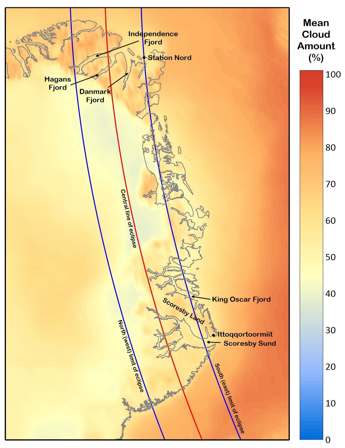
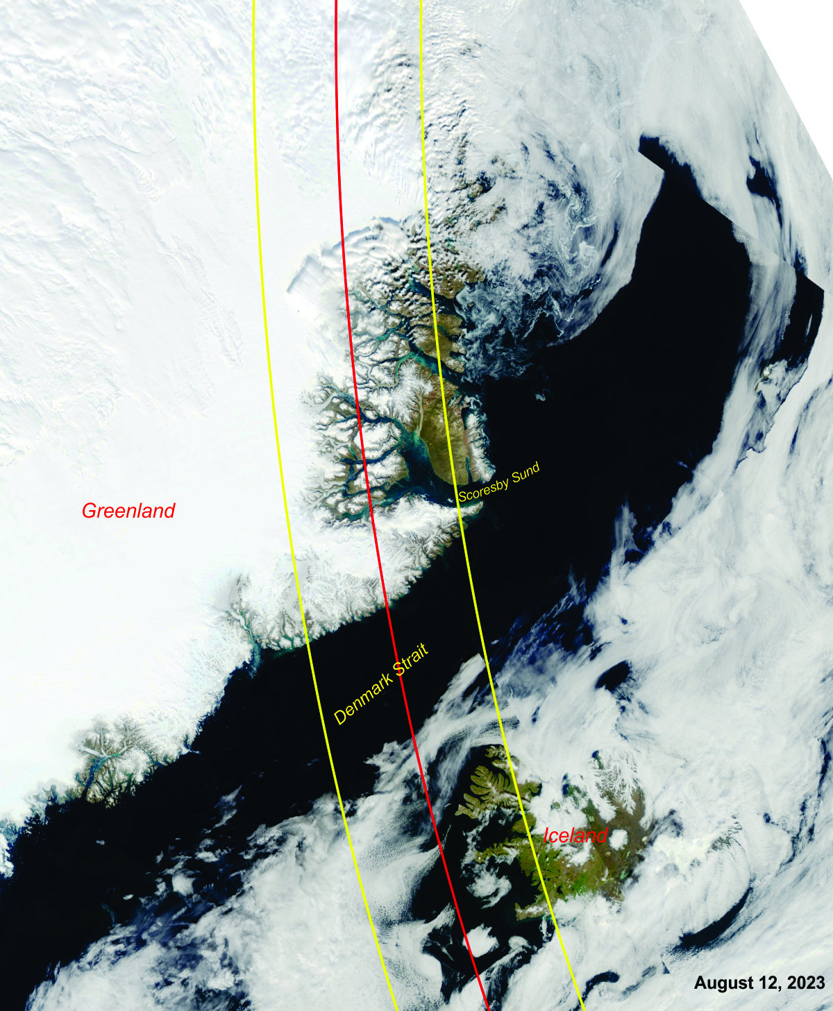
It is only when the track reaches Greenland that the cloud cover surrenders its hold and better prospects appear. Unfortunately, this better weather is on the heights of the ice cap—a region likely to be occupied by a few lucky researchers if at all. However, as the cold, dry air spills off of the icecap into the fjords, the air is warmed and further dried by its descent, a feature known as a chinook in much of North America and as a foehn in other parts of the world. The deepest of the inlets, Scoresby Sund, slice right to the centreline of the eclipse track and even a little beyond (Figure 2), sampling the clear, dry air that descends from the frozen heights.
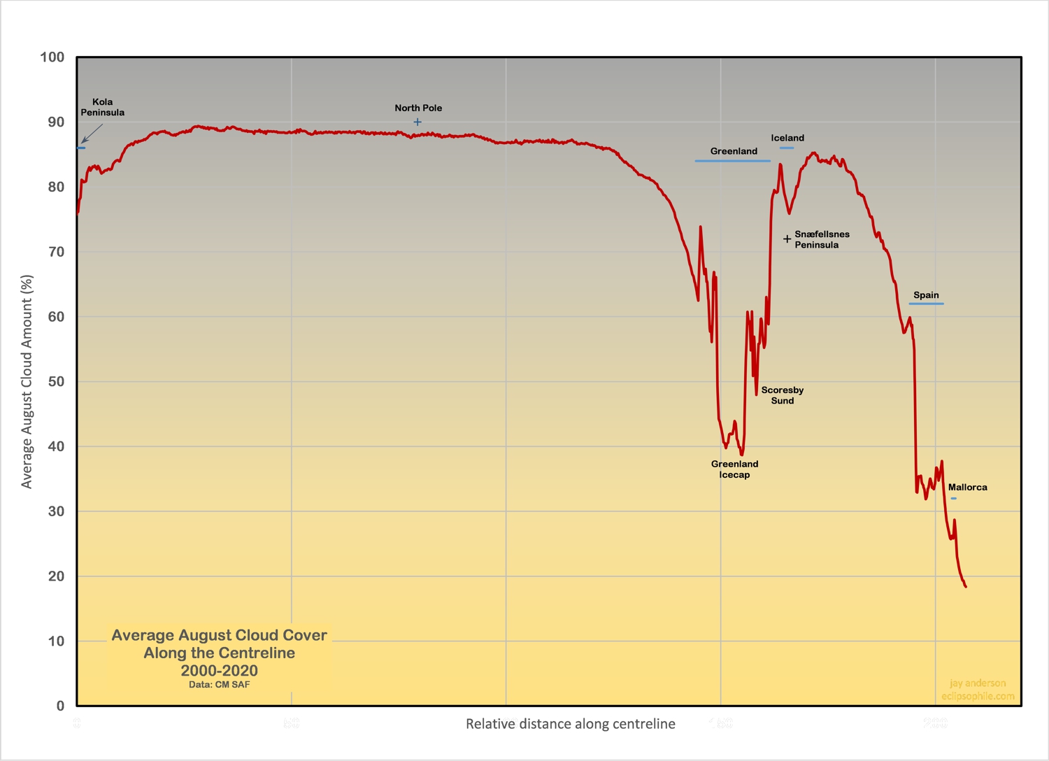
Satellite measurements of August cloud cover along the Greenland coast show that the deep reaches of Scoresby Sund have a mean cloudiness just under 50 percent, as shown in Graph 1. There are no sunshine measurements under the track in this part of the globe, but Ittoqqortoormiit, a village at the entrance to the Sund, records an average August sunshine amount of 40 percent of the maximum possible (Table 1). The corresponding satellite-measured cloudiness at that location is around 65 percent, which fits nicely with the ground station observations, but a trip deeper into Scoresby Sund puts the observer into a location where the satellite measurements of cloud cover for August drop to 45 percent.
Examination of 20 years of satellite images over the Sund offers an even more optimistic picture of Greenland coastal cloudiness. Automated satellite cloud measurements have problems with detection over icy terrain, whereas a human can recognize terrain patterns and use animation to distinguish cloud from ground. Over the 21-year record of satellite observations, Aqua satellite images (acquired around 1:30 p.m. local time) show that the eclipse would have been easily visible in clear skies on 13 occasions from the centre line in Scoresby Sund and visible through thin clouds on another 4 dates. That’s an impressive success rate of 80 percent. A location on the east edge of the shadow track close to Ittoqqortoormiit was slightly cloudier. While 21 days is a small climatological sample, it demonstrates that the interior inlets of Greenland might be very good eclipse-watching sites. Fortunately, Scoresby Sund is a favourite destination of cruise boats sailing from Iceland.
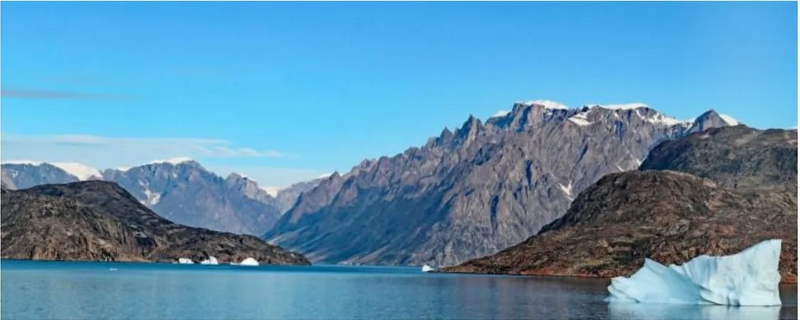
The best-positioned land-based location is likely Nord Station, a military and research outpost that lies about a half kilometre inside the southern edge (now the eastern edge) of the umbral track in northern Greenland. Ittoqqortoormiit, a small settlement of several hundred souls, lies nearly 50 km outside central eclipse limit. Farther west lies Igtaralivit, 32 km outside the umbral zone. You can explore these communities and the nearby coast on Google Streetview (perhaps better titled “Boatview”) if you wish, but reaching them requires a bit of hip-hop travel. Ittoqqortoormiit can be reached by flights from Iceland (Norlandair) , landing at Nerlerit Inaat Airport, about 40 km from the settlement. From the airport, a short helicopter flight will complete the trip to Ittoqqortoormiit. After that, you are on your own to get into the shadow path and it will have to be by boat.
Iceland
Iceland is a destination of striking beauty—an island of volcanoes, glaciers, and aurorae. Alas, it is also a land of plentiful cloud and frequent precipitation, as befits its location astride the North Atlantic’s main storm track and cheek-by-jowl with the Icelandic Low, a semi-permanent low-pressure system where North American storms go to die. Its terrain is complex, with strong meteorological influences from both elevation and proximity to water. In spite of this gloomy assessment, there are some locations and strategies for movement within the eclipse track that may greatly improve an observer’s odds.
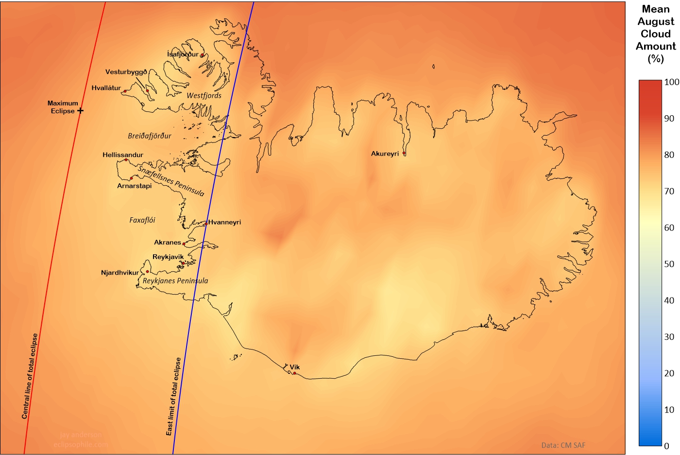
While it’s small consolation, the island is actually sunnier than the nearby waters of the Iceland Sea. It’s not a large benefit—according to satellite observations, cloud cover averages about 70 to 80 percent generally across the island compared to the 80 to 90 percent offshore. Cloud cover over the land has a different character compared to that over water. While over-water cloud tends to come in large broken to overcast sheets, cloud on land is more convective, broken up by the flow over the terrain and by the heating of the land in the daytime.
Much of the weather is dictated by the wind—so much so, that the Icelandic Met Office begins the forecast for each region with the wind direction and speed. Air piles cloud up on windward sides of the island and opens skies on the leeward side. Classically, one or more of the several peninsulas that extend into the eclipse zone will have dense cloud on their upwind side and nearly clear skies on their lee.
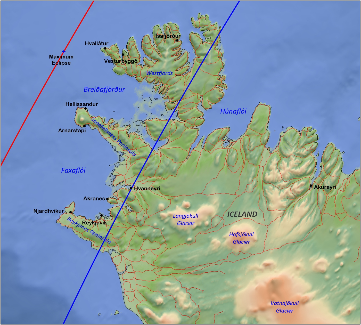
The western peninsulas—Westfords, Snaefellsness, and Reykjanes—seem especially sensitive to convective clouds, which tend to build along the mid-line of the peninsulas on sunny days, leaving the surrounding coast in clear skies. On such days, the best eclipse sites are those that lie within sight of the sea, provided the day promises to be at least partly sunny. The three peninsulas are very nearly equal in their cloud averages, and so the eclipse traveller is left with the choice of watching from Reykjavik, heading northwest to get as deep as possible into the shadow, or, best of all, following the forecasts the days before the eclipse to find the most promising spot. Completely overcast skies across the island are in the minority, but finding an opening can be a challenge, especially if significant travel is required. The Icelandic Met Office displays a cloud-cover forecast map on its web site (https://en.vedur.is/weather/forecasts/cloudcover/), which could prove invaluable for planning and site selection before eclipse day.
Ground-based sunshine measurements within the track are available only from Reykjavik and show that the sun shines on 32 percent of the daylight hours in August. This fits well with the mean cloudiness of 71 percent as measured from satellite. Most foreign travellers will find that August weather is cool, with highs in the mid-teens and lows in single digits (Celsius), but current global warming trends are bringing occasional highs into the mid-20s.
The North Atlantic Ocean
As the track moves southward, past the latitude of Ireland, it begins to move into a high-pressure ridge extending across the Bay of Biscay into France from the mid-Atlantic, subtropical Azores High. While the ridge has a somewhat variable character, its on-again, off-again presence can be detected in the gradual diminution of cloud cover along the eclipse track, from around 85 percent off Ireland to 60 percent as the shadow path approaches the coast of Spain. On any given day in August, the North Atlantic plays host to one or more low-pressure systems with extensive cloud cover, but there are always scattered holes in the sky cover, sometimes fairly large.
Iberia and the Balearic Islands
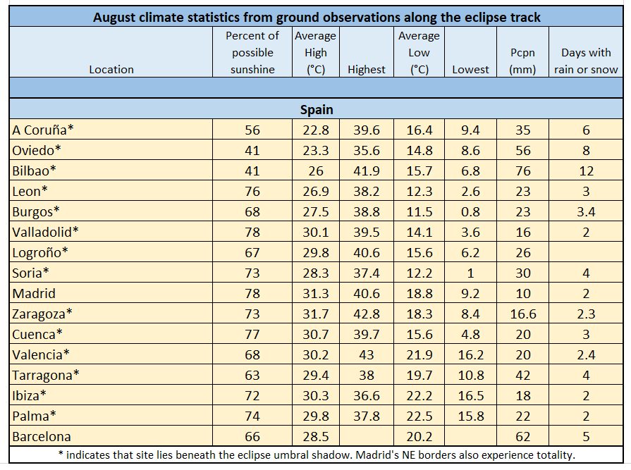
Spain’s summer climate (and a very tiny part of Portugal’s) is one where sunshine dominates, with August’s percent of possible sunshine (the percentage of sunny hours between sunrise and sunset) generally lying in the 70s percent range along most of the eclipse track (Table 2). It’s not an evenly spread cloudiness, as certain parts of the country are more sensitive to the formation of cloud than others. Eclipse travellers will find considerable value in paying attention to the nuances of Spain’s climatology and topography together.
Viewing the eclipse in Spain is complicated by the low sun, only 10 degrees of elevation on the north coast and a mere 4 degrees above the horizon at the Balearic Sea during totality. The view to the Sun must be clear at the horizon whatever may be present in the rest of the sky. In the latter parts of the eclipse track, care must be taken to avoid hills along the horizon or an unfortunately placed forest.
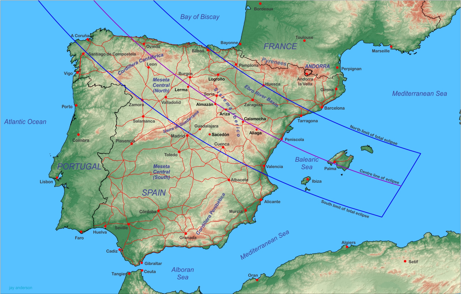
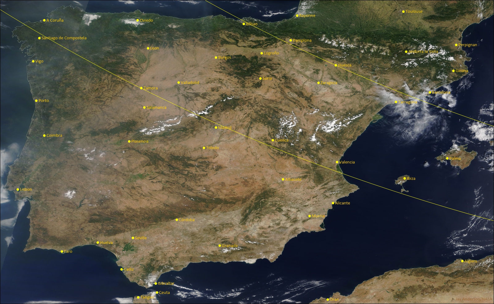
The Iberian Peninsula has a rugged topography that is defined along the eclipse path by three mountain ranges, two elevated central plateaus, a river valley, and two coastal plains (Figure 5). In the north, the Cordillera Cantabrica blocks moisture from the Bay of Biscay, holding it against the coastal lowlands and preventing its intrusion into the central part of the peninsula. There are gaps in the barrier, primarily on the north side of the central line, between Bilbao and Burgos, but even there, the the moisture invasion is usually slowed by the 1000-m heights northeast of Burgos.
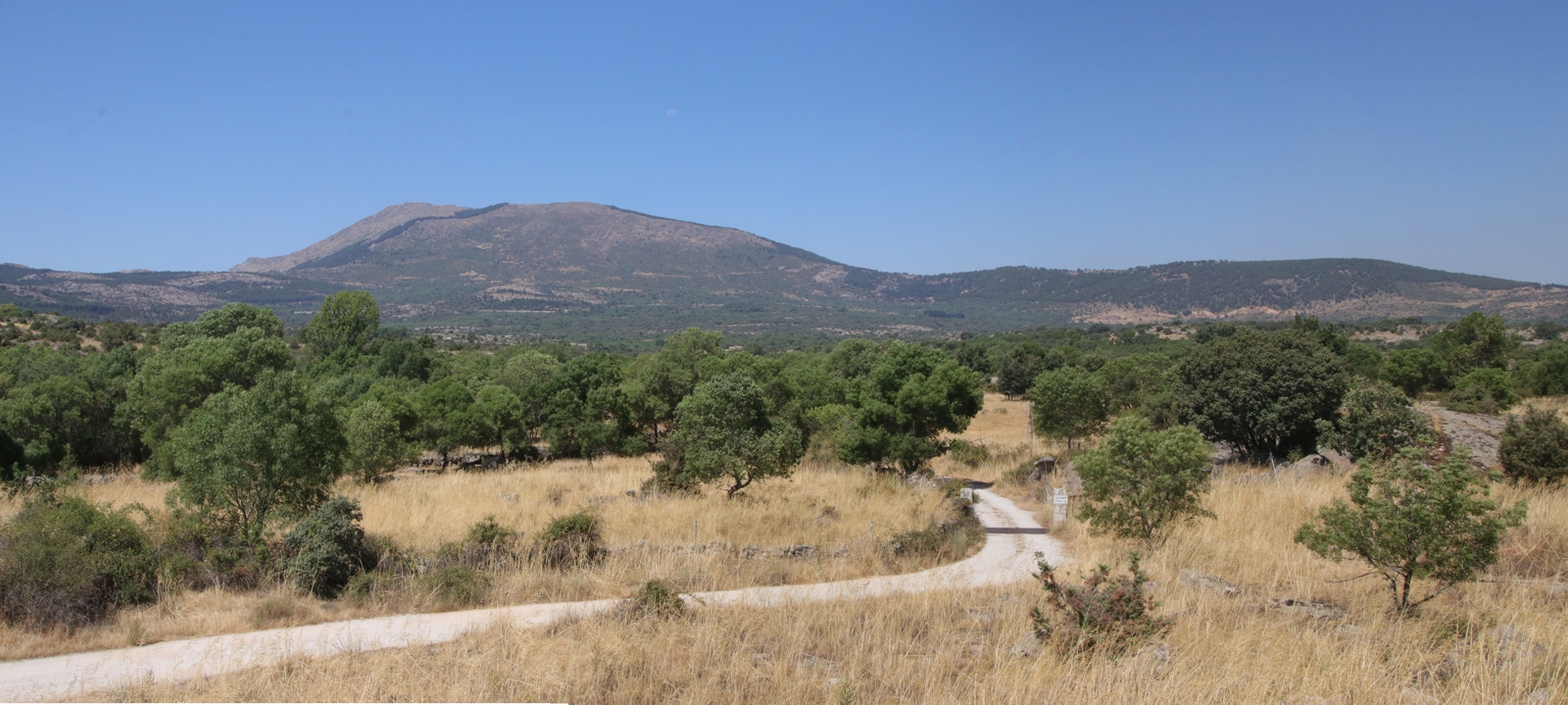
In central Spain, the eclipse track moves onto a much more complicated landscape. On the north side of the central line, the shadow falls mostly on the lowlands of the Ebro River Basin. On the south, it crosses the Meseta Central (Figure 7), an elevated 600-700 metre plateau that is split into a north and south part by the Sierra de Guadarrama, a range of mountains lying north of Madrid. The Sierra is generally about 1000 m higher than the Meseta, but reaches 2400 m ASL at its highest point.
The Sistema Iberico begins southeast of Burgos and arcs southward, at first on the north side of the central line, but then spreading across almost all of the south side of the track as it approaches the Mediterranean coast. It is a haphazard collection of at least seven smaller ranges and massifs, separating the Meseta from the Ebro River Basin in the north and from the Mediterranean coast in the east. Peaks in the Iberico are modest, reaching about 2300 m.
Cloud and weather in Spain
All of this up-and-down topography has an impact on the cloud climatology of the Iberian Peninsula. In Figure 8, we see the broad outlines of the terrain mirrored in the cloud patterns (compare with Figure 5). Higher-cloud yellow tones largely lie atop the elevated terrain, while blue shades spread across the lower elevations of the Meseta basins and the Ebro Valley. The differences in cloud amount are relatively small once the track has crossed the Cordillera Cantabrica, especially along the central line, which dodges between the good- and poor-weather regions but always stays around 35 percent.
Mountain ranges force air to rise, causing it to cool and condense into cloud. In Spain, the mountains are covered in dark forests that absorb sunlight, warm quickly in the high summer sun, and blossom with convective clouds whenever the atmosphere is sufficiently unstable. The location of these low-albedo forests can be seen in Figure 9, which also shows convective clouds beginning to develop over some of the darker regions.
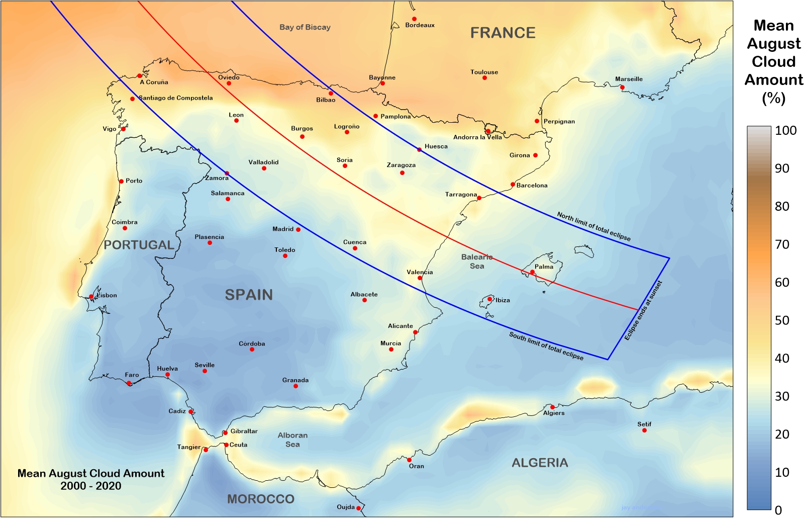
In Figure 8, we see that the north coast along the Bay of Biscay is an uninviting destination for eclipse viewing. The data tell the story: satellite-measured cloud amounts are universally close to 60 percent (Graph 2, above and centre) and the percents of possible sunshine (Table 2) for Oviedo, Bilbao, and A Coruña are the lowest on the track.
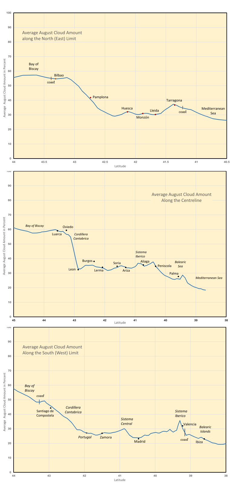
The Cantabricas are highest on the south side of the track and across the eclipse midline, but peter out toward the north limit, allowing Atlantic cloud and weather to move farther inland, up to Logroño and Pamplona and almost to Burgos. The mountain topography shows up in differences between north-side and centreline cloudiness in Graph 2: there is an abrupt transition from cloudy to sunny in the traces along the centreline (middle), but a more gradual one along the north limit (upper graph) where the lower elevations allow the moisture to penetrate inland.
Cloud over the north coast comes from a variety of sources. Mostly, it’s just a pile-up of stratus and stratocumulus clouds driven ashore onto the mountain slopes by northerly winds. Occasionally, cold fronts sweep inland from the Bay of Biscay, pausing on the Cordillera before spilling across the peaks onto the Mesetas. Convective cloud, including large thunderstorms, build on sunny but unstable days (usually behind a cold front), smearing upper levels of the atmosphere with a cloudy debris. In addition to the cloud, exposure to a cold ocean brings temperatures that average several degrees lower than the rest of the Iberian eclipse track and rain comes two to four times more often in the month.

Examination of satellite images from 2001 to 2022 reveals that the eclipse would have been easily visible on only 10 of the August 12s along the north coast; the eclipse would not be seen on 9 of the days. The remainder were uncertain, depending on precise local circumstances.
Once over the Cordillera Catabrica, the eclipse track adopts a Jeckyl-and-Hyde personality. Wherever the track crosses forested terrain, the level of cloudiness rises; on the flatter and lower parts, it declines. In Figure 8, the cloud over the Sistema Iberico is visible as a pale yellow band from Logroño to the coast north of Valencia. About half-way along, a pale orange finger of higher cloud extends southwestward from Soria almost to Pladencia, passing north of Madrid. This finger marks the influence of the Sierra de Guadarrama and is most noticeable in the bottom figure of Graph 2, where it imposes a “penalty” of about six percent in average monthly cloudiness. Madrileños—citizens of Madrid—use the heights of the Sierra de Guadarrama to escape from the summer heat of the city or enjoy a picnic, but it will require some exploration to find a convenient eclipse vista from the mountains since they are heavily treed and only face the low evening sun on their north side.
Leon, Burgos, and Valladolid are three prominent destinations in the north basin of the Meseta Central and show average August sunshine amounts of 68 to 78 percent in the statistics of Table 2. Daily images from polar-orbiting satellites since 2001 suggest an easily visible eclipse on 17 days of 21. In the south basin, Madrid, Cuenca, and Guadalajara lie in the sunniest zone.
Perhaps the most complex region to watch the eclipse is in the various mountain ranges of the Sistema Iberico. The landscape provides spectacular vistas toward the setting sun, but the cloud cover map in Figure 8 suggests a certain amount of caution, especially with such a low solar altitude at eclipse time. The colours in Figure 8 seem to promise dismal prospects for the mountains, but the actual measurements range from 35 to 45 percent in the area between Soria and Logroño—fairly decent numbers. Surface measurements of August sunshine show an average of 67 percent of sunny hours at Logroño and 73 percent at Soria. The difference in cloud cover between the best and poorest sites in central Spain is not very great—usually less than 10 percent.
Some of the best cloud prospects lie atop the floodplain of the Ebro River, around Huesca and Zaragoza. August cloud cover is in short supply here: Zaragoza has the largest percent of possible sunshine (Table 2) in the region. The central part of this region enjoys a cloud climatology that drops below 30 percent—about as favourable as the central Mesetas—provided the observer avoids the coastline near Tarragona. The countryside between Zaragoza and Huesca leads a charmed life in satellite images, as the region is often clear of cloud when all around is suffering. Examination of daily images reveals that a site at Zaragoza would have had an easy view of the eclipse on 18 of 21 years. Though there is a penalty to pay in eclipse duration and elevation, this region will be an attractive site in which to wait for totality and a fascination low-altitude eclipse.
As the eclipse track approaches the Balearic Sea, it crosses a low range of hills and descends onto the coastal plains. Cloud here is most often convective, fed by a nearby marine moisture supply. Moisture moving inland soon runs up against the eastern bulwarks of the Sistema Iberico where the rising topography promotes the formation of cloud.
Cloud cover on the Balearic Islands is least on the coasts, particularly on the west side, facing the setting sun. The higher interior terrain is often dotted with cumulus clouds in the afternoon, but the cool breezes on the coast suppress them for a few kilometres inland. For such a low view toward the sun, the skies must be very clear, a condition that is not particularly reliable. Of course, the reward is a spectacular eclipse, just off the horizon, likely with a football-shaped (American football) solar orb and a red-tinted corona only 2.5 degrees above the horizon. If it works, you will go home with a lifetime picture. Past satellite images suggest that you will have about a 75 percent chance of success.
Weather systems
The eclipse track crosses Spain between latitudes 44 and 39, and so is affected by transitory mid-latitude highs and lows along with their associated warm and cold fronts. These systems lose some of their intensity in crossing mountain barriers, particularly when approaching from the northwest, but for the most part, the mid- and high-level clouds sail over the mountains without much impediment. Once over the peninsula, these systems promote the development of convective clouds. Completely overcast skies are rare under such circumstances, but the low altitude of the Sun at eclipse time makes even thin cloud important.
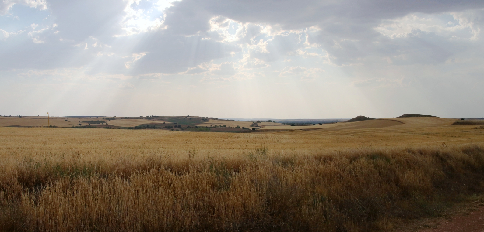
Over the Mesetas, convective cloud often forms during the late morning and afternoon (Figure 10). Most often the earliest buildups of the day and the most intense in the late afternoon are found on the slopes and peaks of the mountains. As the cloud builds over the heights, it usually spreads out across the lower-level surroundings, generating new convection to plague the eclipse-seeker. Spain is not immune to severe thunderstorms and large convective outbreaks, similar in character to those in the United States, and these systems are not wedded to the mountain slopes. The plains of the Mesetas blossom with these buildups whenever moisture and instability are present and their predictability is limited.
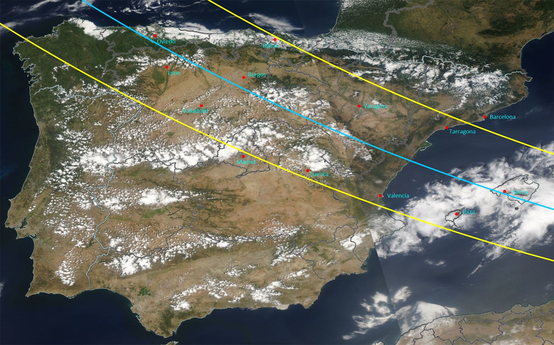
Sunset eclipses from the slopes can present a stunning scene to the observer, but the watchers place themselves in a precarious position, hoping that cumulus development doesn’t build into a sun-cloaking rainshower or thunderstorm. Falling temperature as the eclipse approaches will take away some of the energy that fuels the buildups, but only the smallest will fade away; larger convective clouds will continue past sunset and into the evening. It’s probably a good idea to avoid forested terrain if the day’s forecast is unfavourable.
In addition to the cloud-producing weather systems and instability, summertime Spain is occasionally plagued by strong southerly winds that carry Saharan dust and extremely low humidities onto the peninsula. Such “calimas” affect southern regions most dramatically, sometimes tinting the sky orange and reducing visibilities to very low values. Another form of calima, now becoming more common, is the haze created by forest fires. Observers would have to be relatively close to a forest fire to block the view of a setting sun, but if smoke is widespread, the view of the eclipse will suffer.
Exploring further
NASA’s Earth Observing System Data and Information System (EOSDIS) site. At EOSDIS you can examine daily global images from polar-orbiting satellite back to 2001, zooming into prospective eclipse-viewing sites. The images are limited to mid-morning and mid-afternoon overpasses, which is earlier than the late-day eclipse, but the overall character of the weather revealed in the images will make you more familiar with the task you will encounter in 2026.
Good luck!
February 2023
Return to eclipsophile.com home page
