Annular Solar Eclipse
February 6, 2027
The 2027 annular eclipse presents South America with its fourth eclipse within the preceding decade. It’s not exclusively a western hemisphere event, as, on the opposite side of the Atlantic, the shadow of the Moon just touches the coast of Africa as the sun sinks toward the evening horizon. Two continents, many cultures.
February is late summer over Chile and Argentina (equivalent to August in the north) and temperatures are warm, sunshine abundant, and monthly precipitation is close to its minimum for the year. In Argentina, thunderstorms are a daily feature in the afternoon, especially in more northerly parts of the track. In Africa, dry-season skies are seemingly not as sunny as in South America, but cloud cover there is likely to fade away with the approaching shadow. The main bug-a-bear along the African coast is Saharan dust. It’s endemic and it is more likely to be present than not.
Chile
Lying against the Pacific Ocean and hemmed in by the Andes Mountains, Chile is assured a cloudy climatology, though February is a relatively friendly month as far as sunny skies and dry weather are concerned. In addition to their impact on the weather, the mountains and indented coastline inhibit the ability to travel along the track. On land, access to eclipse-watching sites is restricted to three highways that cross the shadow path, one on the Isla Grande de Chiloé and two on the mainland.
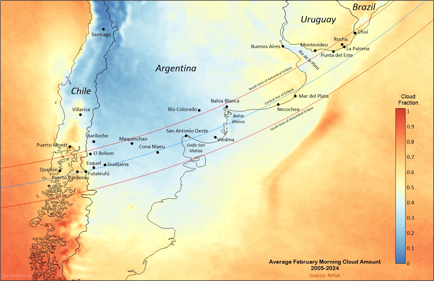
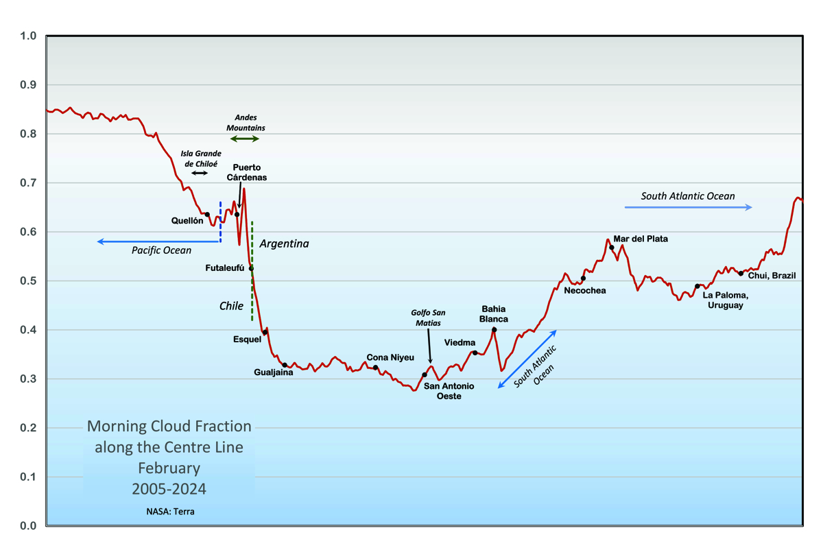
The map in Figure 1 and the graph of centre-line cloudiness (Figure 2) show the satellite-measured February cloud cover along the shadow track. At Quellón, on Chiloé, and at Puerto Cardenas on the mainland, the satellite sensors detected an average cloudiness of around 0.63 (i.e., 63%). At Futaleufú, near the Argentine border, it was about 10 percent less. The cloud fraction rises to nearly 0.7 as the track crosses the peaks of the Andes and then declines rapidly as it moves toward the Argentine border and settles onto the pampas. Weather systems dry significantly in their passage over the Andes, and so Futaleufú has the meager honour of the better weather prospects in Chile, even though still embedded within mountainous terrain.
Sunshine measurements are only available for Quellón, which show amounts in the mid-fifties percent (Table 3). Visual inspection of individual Terra satellite images (Terra’s morning passage is approximately at eclipse time) shows that at both Puerto Cardenas and Quellón, a successful view of the eclipse would have been likely on 13 days out of the 23 years of satellite data. These numbers match well with the percent of sunshine recorded at Quellón, but are more optimistic than the satellite reports. Satellites don’t “see” the small openings in cloud on a day with convection, which is relatively common during the Southern Hemisphere summer.
If you like adventure touring, Futaleufú with its world-class whitewater rafting may suit your tastes. February is the driest month, but precipitation can be expected on an average of 6+ days of the month. There are no sunshine records for the community, but Terra satellite observations recorded an average cloudiness of 52% over 22 years of Februaries. Examination eclipse-day satellite images over those years showed that the sun would have been visible on at least 15 days, though many of them had to deal with transparent clouds.
On the Isla Grande de Chiloé, all but the northernmost 40 km of the island lies within the antumbral shadow, but the main road (Highway 5) ends at Quellón, about 45 km short of the central line. Highway 5 was partly hard-surfaced and partly gravel in 2014 but seems to have been upgraded in the intervening decade. A ferry crossing is required to get to the island. On the mainland, the centre line lies 15 km south of tiny Puerto Cardenas, accessible along Highway 7 between Puerto Cardenas and Villa Santa Lucia. Santa Lucia is the larger community but was mostly buried by a huge landslide in 2017. Google Earth images from 2021 show that at least a part of the community is still functioning and the highway has been restored.
Futaleufú can be reached by travelling 100 km onward from Puerto Cardenas, or more easily, by Highway 259 from Argentina, though in doing so you would be leaving a much better climatology in Patagonia for that in the mountains.
All-in-all, if you go to Chile for this eclipse, you likely have a 50-60% chance of seeing it. You will, however, be treated to a spectacular scenery enroute.
Argentina
Ten kilometres beyond Futaleufú will bring you to the Argentine border, through a landscape of fast-moving rivers and 2000-metre mountain peaks. A further 40 km will take you to Trevelin and out of the Andes Mountains; a half-hour more will bring you to the largest community in the foothills, Esquel. From there, it’s a few additional minutes of driving and the eclipse track moves out onto the Patagonian plains.
From the mountain peaks along the border to Esquel, the centre line experiences a sharp drop in altitude, losing about 1600 metres in elevation to arrive on the gravel plains and desert climatology of Patagonia. The cloud fraction along the centreline drops nearly 30 percent, as the bulk of the cloudy weather is left behind on the mountains. Patagonia is a rough, windy landscape with blowing dust and frosty nights, but in February, the weather systems are tamed somewhat and the more extreme weather is left to later, colder seasons.
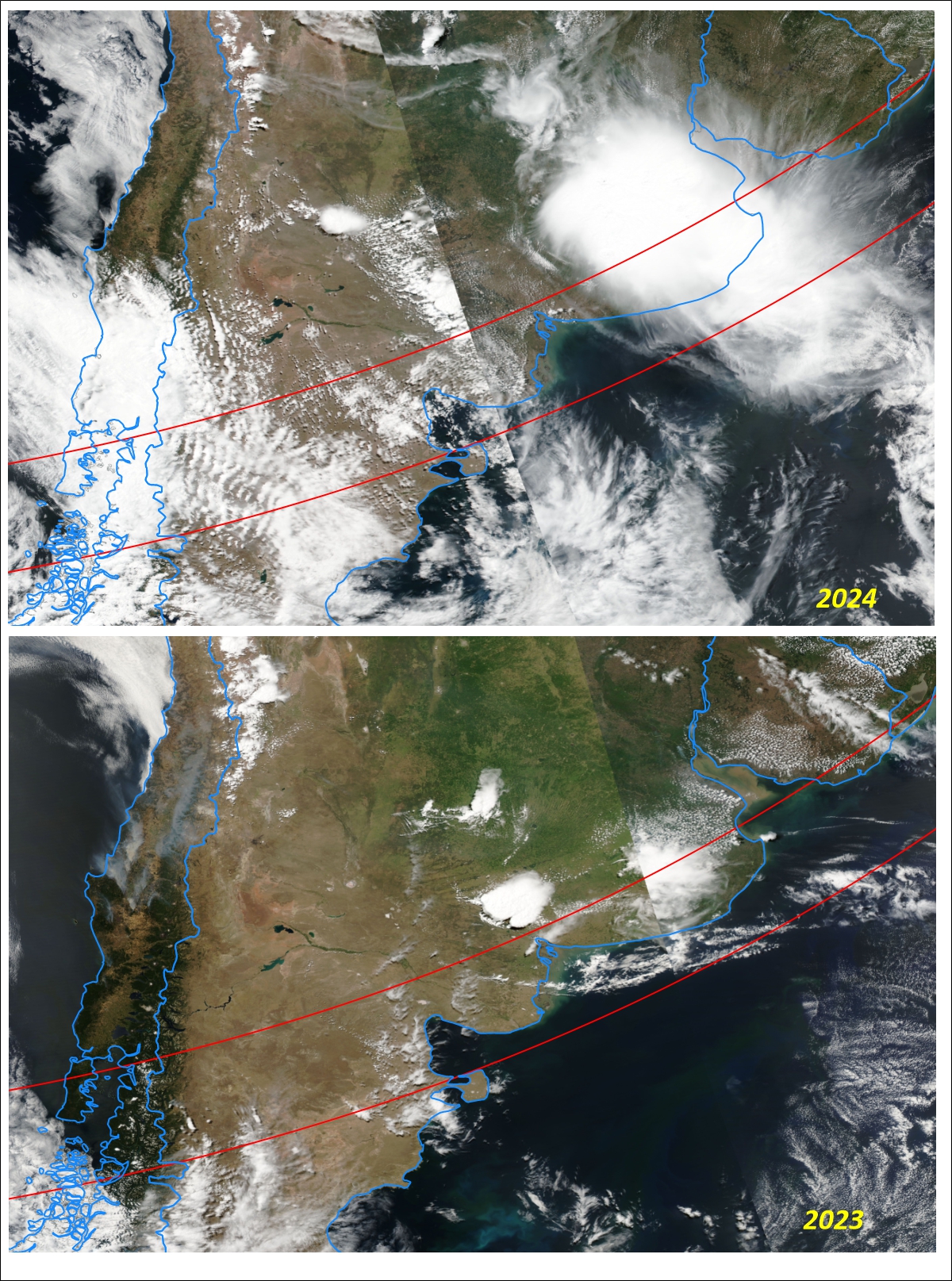
Most cloud cover along the Andes foothills is generated by the flow over the mountains. While moisture in lower levels is blocked by the mountains, mid- and high-level moisture passes overhead and is lifted upward and turned into cloud that then flows downwind across the plains. The cloud is often arranged in bands parallel to the mountain chain, forming bands of clear and cloudy skies (Figure 4). These lee wave clouds are typically quasi-stationary and so can be utilized by positioning yourself in one of the open patches with some assurance that they will not move out of the way over a short interval. The openings are not very large—a few kilometres, likely—and so accurate positioning will require the ability to move eastward perpendicular to the mountains—not an easy task in the limited road networks in the area. Unfortunately, the sunny spot might not become evident until close to 2nd contact.
At Esquel, against the Andes Mountains, February cloud conditions reflect its location to the lee of the higher terrain. Terra data show an average monthly cloudiness of 40 percent and historical satellite images show that the eclipse would have been visible on 16 days of 23. Sunshine measurements average 64% of the maximum possible—not the best along the path, but better than most. By moving a little farther east, conditions improve by another 5 to 8%.
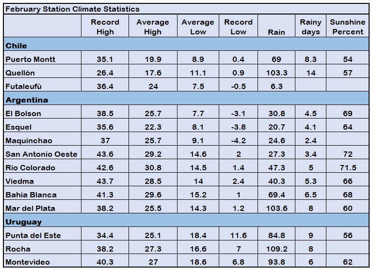
If you aren’t too fussy about being on the centerline, or want to hang out near the north limit to watch the beads roll around the limb of the Sun, then El Bolsón might be to your liking. It has a sunny disposition, with the local weather station measuring an average February sunshine amount of 69%, just a few percentage points less than farther along the track. Terra gives it an average cloudiness of 40 percent. The day-to-day assessment of eclipse-viewing potential since 2001 is equal to Esquel, with 16 days over the years clear enough to see the eclipse.
Away from the foothills, from the archeologically interesting town of Gualjaina to the Atlantic coast at San Antonio Oeste, Terra-based cloud statistics show an average of 30 to 35 percent cloud cover along the centreline, making Patagonia and the adjacent Pampas the sunniest region along the eclipse track. These favourable statistics are only marred by a lack of easy access and the absence of large communities along the centerline.
Most routes that cross the eclipse track are rough gravel roads. The better quality Highway 23, from the Atlantic coast to the Andes, runs inside the eclipse track for the most part, but it’s close to the north limit until it joins with Highway 40 and turns toward Esquel in the mountain foothills. The highway passes through two large communities, Ingeriero Jacobacci and Maquinchao, which might provide a comfortable staging point for an eclipse expedition.
As the shadow path approaches the Atlantic coast, it moves into a more humid, temperate climate and then, as the path continues northeastward, to a subtropical environment. The transition to a wetter climatology comes after the track passes San Antonio Oeste, and so that this waterfront city and its surroundings have the (slight) distinction of being the sunniest along the shadow track. Terra satellite observations display an average cloudiness of 28% at a point southwest of San Antonio. Weather station measurements in the city show an average sunshine amount of 72% in February hours over the past decades. Scrutiny of February 6 satellite pictures over the 23 years since 2001 (one year was missing) revealed what would have been a successful eclipse day on 20 of them.
From an eclipse chaser’s point of view, the variations in cloud cover and sunshine measurements across Patagonia and the Pampas are not significantly different from each other. The afternoons tend to be cloudier inland as the sun warms the ground and builds convective clouds, but the eclipse shadow will be long departed before temperatures reach their peak.
On reaching the Atlantic coast, cloud cover along the eclipse centreline begins to climb, rising 10% between San Antonio Oeste and Bahia Blanca as the track moves along the South American seaboard. Beyond Golfo San Matias, the north limit remains over land for the most part while the south limit remains at sea. The centerline moves back and forth between land and ocean, with gradually increasing cloud amounts, especially over land. The centerline graph shows that cloud decreases as the path crosses Bahia Blanca (south of the city of the same name) before climbing rapidly as it moves back onto land near Nechochea and Mar del Plata.
Through the region from San Antonio to Bahia Blanca, the satellite cloud map in Figure 1 shows slightly sunnier conditions inland, on the north side of the track, with average cloud amounts in the low 30s percent. Sunshine measurements at Rio Colorado, just outside the path, support the space-based observations with an average sunshine amount of 72%, equal to that at San Antonio.
Bahia Blanca is far from the eclipse axis and has a limited duration (3m 26s), but its weather statistics are encouraging. It has a cloud average of 40% according to Terra observations and a 68% frequency of sunshine according to ground-based instruments. Over the past 24 years, 19 days would have shown the eclipse and 2 more were possible. For access to the eclipse edge, Bahia Blanca is likely your best choice and it’s plenty big enough to find a place to stay. Two hours of travel southward on a paved road will bring you to the centre line and to slightly better weather prospects.
Satellite-measured cloudiness along the shadow axis culminates near Mar del Plata with average monthly amounts just short of 60%. It’s a little sunnier, by a few percentage points, toward the north limit. Surface-based weather station observations are more optimistic and show an average 60 percent of possible sunshine. Much of the change in cloudiness is due to thunderstorms, which now become a part of the daily weather along this part of the track. In the late morning hours of the eclipse, storms are in an early stage of development, but there is often lingering high-level cloud from convective buildups the previous night. Occasional Atlantic storms are also a part of the cloud mix, carrying thick layers of cloud inland.
At Mar del Plata, the centerline leaves the coast and the eclipse is only visible from land over a small part of Uruguay and a tiny nub of Brazil. La Paloma or Punta del Este in Uruguay will be the go-to spots along this coast, only two to three hours from Montevideo and with a five to six-minute eclipse duration. Mean cloud amounts from the satellite observations average around 50 percent, in close agreement with the 56% sunshine measurements from Punta del Este.
Africa
It’s almost sunset when the lunar shadow reaches Africa and the Sun is only 7½ degrees high at Abidjan, Côte d’Ivoire, during maximum eclipse. The centre line remains over the Atlantic, lying 37 km offshore at its closest approach to land at Cape Three Points, Ghana’s most southerly point. Five countries—Côte d’Ivoire, Ghana, Togo, Benin, and Nigeria—share a piece of this eclipse.
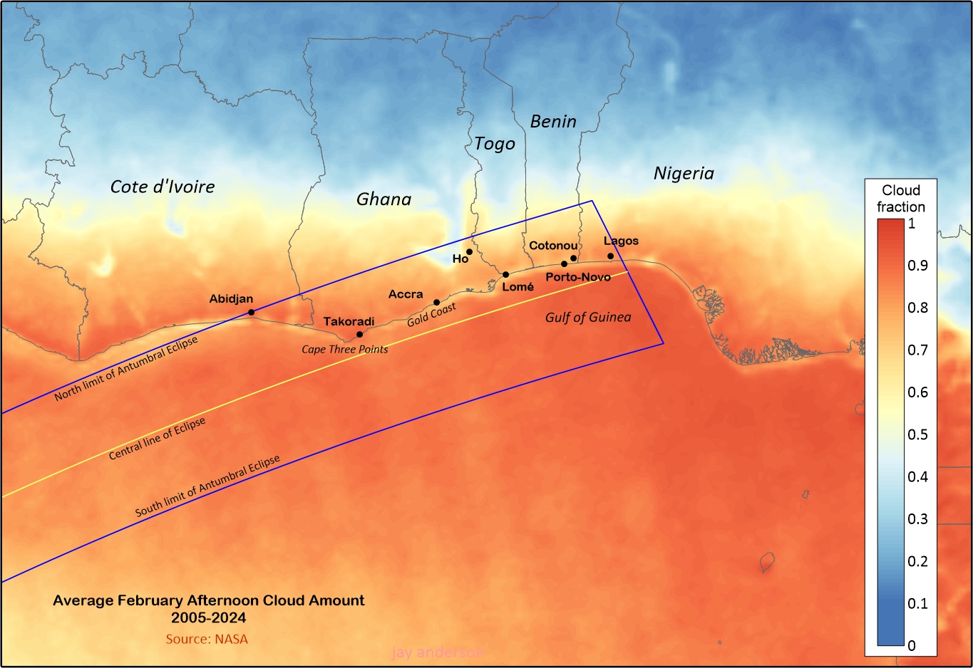
The cloud map in Figure 5, from the afternoon Aqua satellite, seems to present a depressing assessment of the weather prospects. Aqua passes overhead in the early to mid-afternoon, so the cloud map is representative of a time several hours ahead of the eclipse. The satellite images indicate that cloud cover was widespread and heavy along the coast and for 100-300 km inland when the spacecraft passed and likely would be heavier later in the day under normal circumstances.
Fortunately, as least as far as cloud is concerned, the satellite does not give an accurate picture of eclipse-viewing prospects. Almost every day in February the terrain blossoms with small cumulus clouds and this is what Aqua records. However, the cooling effect of the lunar shadow and the late hour of the day will make most of this cloud disappear and the chances of a cloud-free sky along the coast is likely very high. More significantly, daily seabreeze winds bring cool Atlantic air onto shore, pushing back the cloud and giving the beaches and the nearby coast a reliable sunny sky (Figure 7).
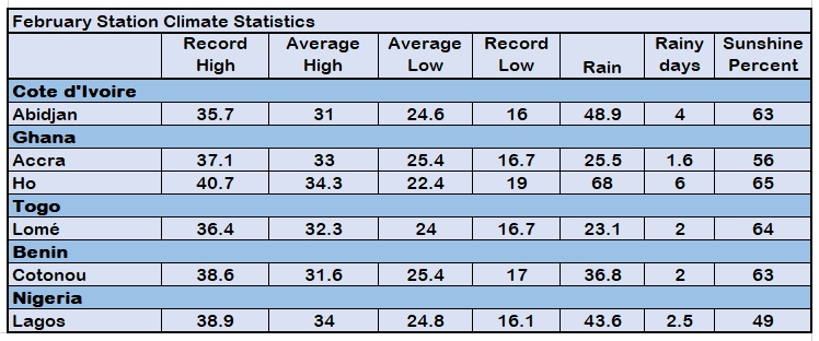
Ground-based sunshine measurements are also affected by the daily cumulus clouds and so the percent of possible sunshine hours are likely pessimistic for the time of the eclipse and the accompanying cooling under the shadow. Nevertheless, that percentage is mostly between 60 and 65 percent along the coast, comparable to those in South America, though the big cities, Lagos (49%) and Accra (52%) lag the rest.
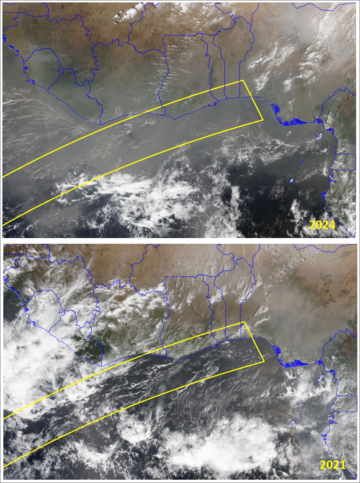
Aqua satellite images captured on eclipse days since 2001 offer a more reasonable perspective on eclipse-viewing possibilities. Sea-breeze winds on days with cumulus buildups clear a strip of the coastline that extends about 10-20 km inland, especially along the Gold Coast from Cape Three Points to Lomé. The clearer weather that comes with the sea breeze is visible in Figure 7 as a band of yellow-toned colour that outlines the coast. Occasionally the same sea breeze winds will generate thunderstorms a little inland along the coast, but these are still likely to leave the coastline cloud-free.
Scrutiny of the February 6 satellite images since 2001 confirm the favourable waterfront cloud diagnosis. When cloud is present, most of the images show a strip of clear skies in a narrow band along the coast, especially along the Gold Coast, from Accra to Lagos (Figure 7). Only one day in 23 years had enough cloud at Accra, Lome, and Lagos to prevent a view of the eclipse—a success rate of more than 90 percent. Takoradi at Cape Three Points had the poorest prospects: the point gets a sea breeze from two sides resulting in colliding wind flows that actually increase the chances of cloud buildups. These might disappear with the cooling during an eclipse, but without an eclipse, only 64 percent of the February 6s had sunny weather.
The cloud statistics are very favourable for eclipse travellers, but there’s one very big qualifier: dust. Almost every one of the February 6s since 2001 had dusty skies over the track. I estimate that 10 of the 24 years had moderate to heavy dust and, with a solar elevation of 6 degrees or lower at central eclipse, you have to question whether the solar ring would even be visible and not lost in the murk on the horizon. Heavy dust obscuration was most likely in the western part of the track, at Lagos, where the Sun is barely above the horizon. In most of the other 14 years, the dust was “light” judging by the surface features visible from orbit, and the eclipse would most likely have been visible for most of them, though partially obscured.
Serious cloud cover, when it does arise, is likely to come from offshore thunderstorms or their remains that spread debris cloud onto the track. That’s most likely at Abidjan in Cote d’Ivoire and least likely in the most easterly part of the track toward Nigeria.
The Gold Coast and its nearby counterparts have a burgeoning tourist industry and a marvelous mix of cultures to sample. There are numerous beach resorts to await the eclipse, particularly in Ghana, and a road network to facilitate movement, though it’s unlikely to be needed. Dust is a problem, but under the right circumstances, might enhance the view of the annulus.
Summing Up
If Western Africa is on your bucket list, then the eclipse will give you a good excuse for an adventure. The eclipse itself may suffer from dusty meteorological deprivations, but the adventure could be grand. Travel is as much a part of eclipses as the spectacle itself.
For best chances of a view of the event, Argentina comes out on top, though without a standout destination from a meteorological point of view. As usual, mobility and reliance on forecasts will offer the best route to success. Mobility is less useful in Africa where sea breeze clearing can almost be guaranteed and dustiness is so widespread as to be inescapable without significant movement.
June 2024