Annular Solar Eclipse
2028 January 26
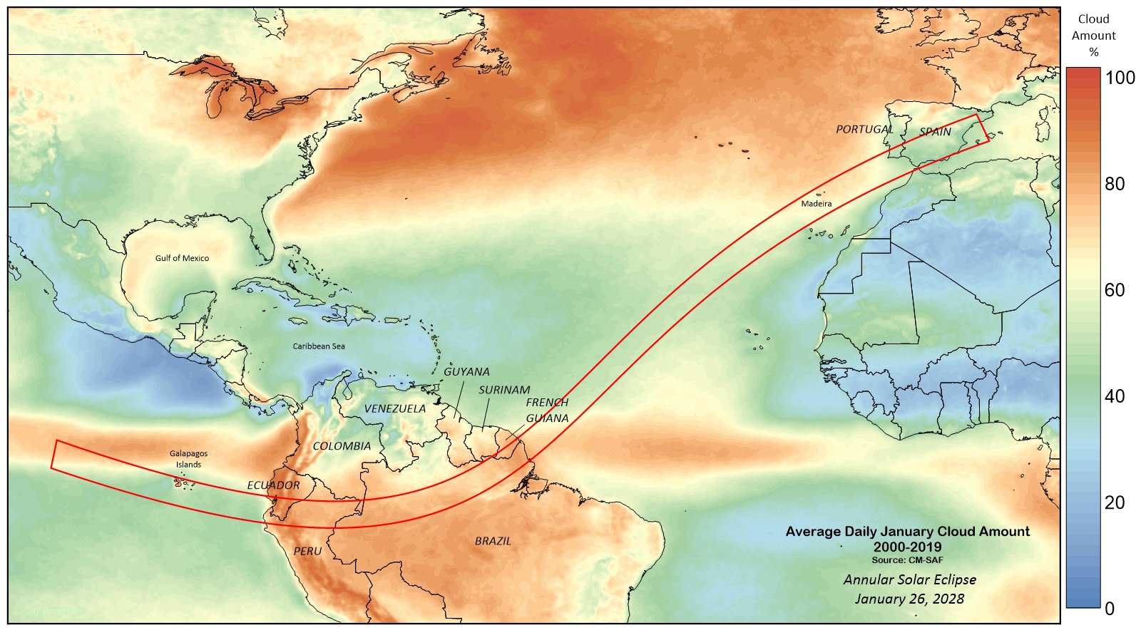
January is not the best month of the year to go eclipse viewing in the Northern Hemisphere. Cold air over higher latitudes pushes the tracks of migrating highs and lows southward and the cloudy Intertropical Convergence Zone, where northeast and southeast trade winds meet, settles along and just north of the Equator. The result is a global track that passes through a succession of cloudy environments (Figure 1; Figure 10) and for which the best weather prospects are largely over water.
Still, in a track that stretches from the Galapagos to Spain, there is bound to be some better-weather sites along the way. This eclipse has three main land-based destinations: the Galapagos Islands, somewhere in the northern part of South America, and the Iberian Peninsula, which will be seeing its third eclipse in three years. Each of these have their cloud oases, but these have to be sought out and often offer only a meagre benefit.
The Galapagos Islands
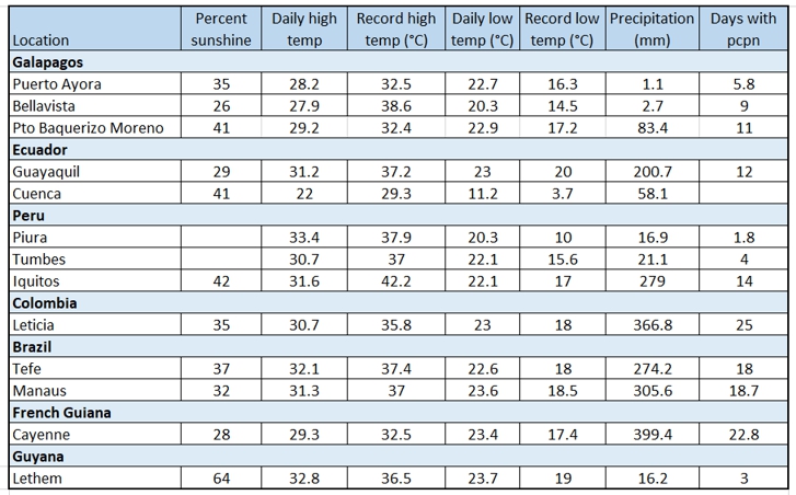
In January, the Galapagos Islands have just completed a transition a cool/ dry season to a warm/wet one. Surprisingly, it’s also a transition from a cloudy climatology to a sunny one. Much of the cloud is convective, of limited extent and forming in the afternoons. Even so, sunshine is not generous as Table 1 shows, with the three reporting stations on the island showing between 25 and 40 percent average sunshine hours in the month. The largest amount of sunshine is at Puerto Baquerizo Moreno, where the flow of wind tends to be along shore rather than onto the volcanic peak.
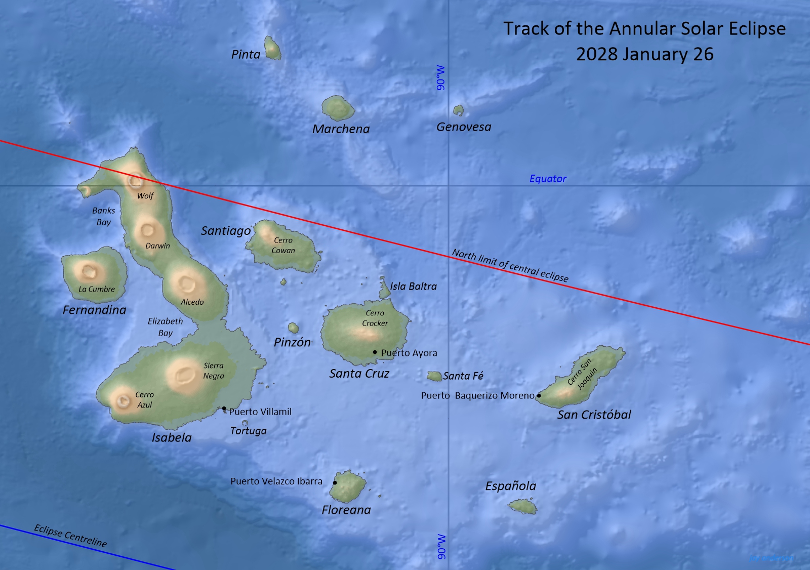
Galapagos weather is strongly dependent on both the flow of wind and the daytime heating of the land. Prevailing winds blow from an easterly quadrant, which piles cloud up on the windward side of the volcanic terrain (Figure 3). This terrain-induced cloudiness is further enhanced by daytime temperatures that generate convective clouds on the higher elevations. These forces—terrain forcing and convective heating, supplemented by the frequent daily passage of cloudy equatorial disturbances—all contribute to weather that changes from sunny to cloudy and back at hourly intervals.
Fortunately, it’s possible to overcome a part of these forces by moving to the lee side of the islands where the terrain is sloping downward (Figure 2), the winds are largely blocked by the volcanoes, and heating of the land is tempered by the nearby presence of the ocean. While such locations are theoretically promising, in reality, there is typically no way to reach them except by boat.
In Figure 3, there are prominent areas on the leeward side of the larger islands that have as much as 35 percent less cloud cover than the higher values on the windward side. The most prominent of these cloud refuges is on the west side of Isabela, south of Fernandina, where the Terra satellite measured an average of just over 50 percent cloud cover for the month.
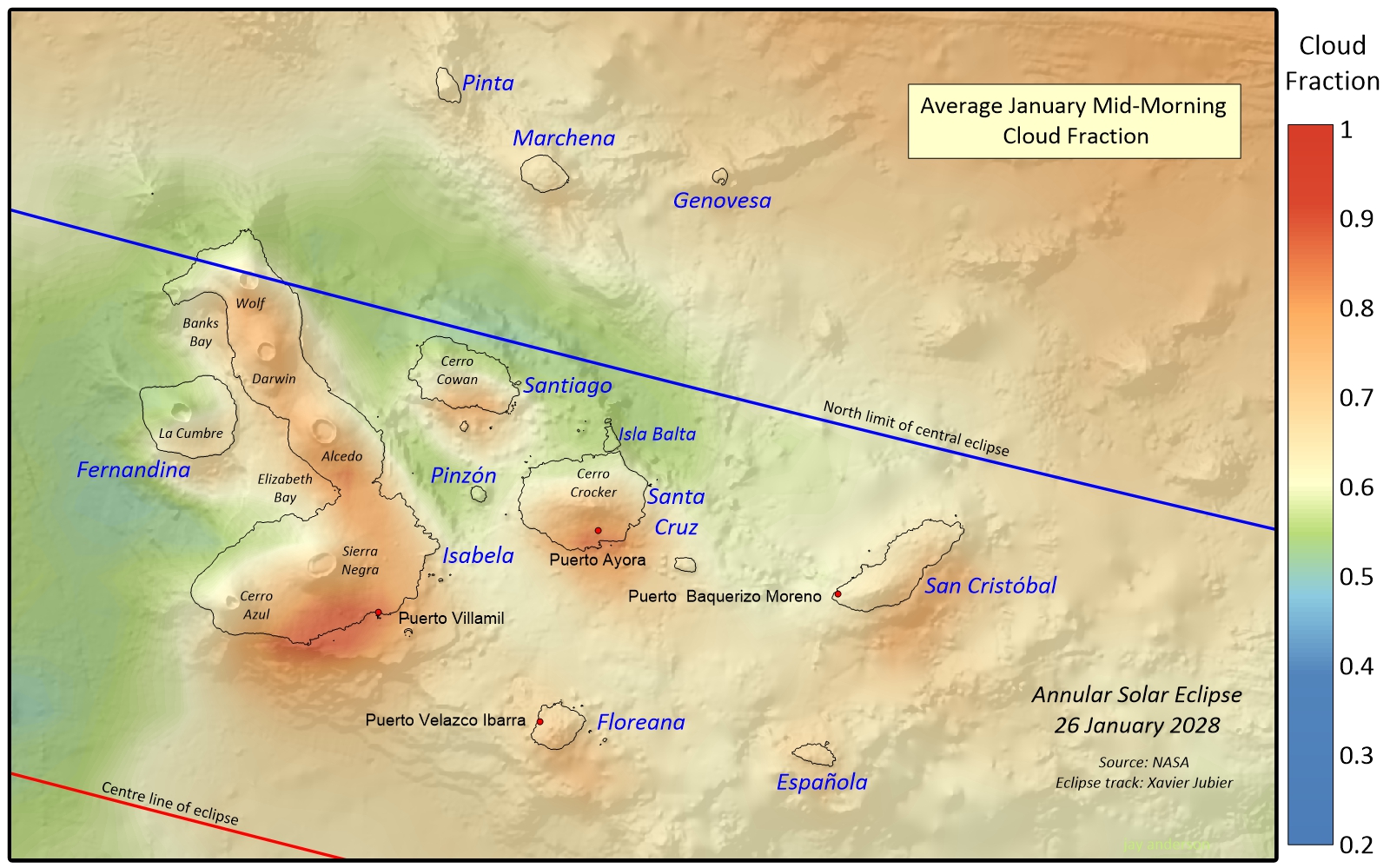
Another promising spot is on the north side of Santa Cruz, on Isla Balta, where average cloudiness is about 55 percent. The island’s lower cloudiness probably arises because of its low elevation, which allows the winds to flow past with obstruction.
Both Puerta Villamil and Puerto Ayora are exposed to the easterlies and on the windward side of volcanoes, and so both have cloud-cover measurements over 80 percent. Puerto Baquerizo Moreno lies on the west side of San Cristóbal and benefits from some protection from the trade winds (easterly winds blow parallel to the coast or are blocked by the island’s volcanic peak) with an average cloudiness of around 60 percent. Isla Floreana, unfortunately, is too small and low to offer the same kind of protection to Puerto Velazco Ibarra; cloudiness there is around 70 percent.
Ground-based measurements of sunshine do not always match easily with satellite observations, since one is a spot measurement and the other is a daily average, but much of the pattern discerned by Terra from orbit is mirrored in the ground-level measurements. From satellite, the greatest amount of cloud is at Bellavista, which lies at 223 m above sea level on Santa Cruz. The least is at Puerto Baquerizo Moreno, for reasons I’ve noted above.
The variability in the present weather from hour to hour is best illustrated by the January 26, 2025 video below, which show the movement and evolution of cloudiness in the morning hours. In the video, the time of the passage of the shadow is marked by a star in the lower left.
Animation of GOES E satellite images on January 26, 2025. The animation begins at sunrise; a star in the lower left indicates the time of passage of central eclipse. Expand the video to see it full screen.
In this animation, clouds arrive, with the low-level winds, from north of east, though, a few small patches of high-level cloud can be seen moving from the south. The loop begins with darkness, as the satellite is not sensitive to low light levels, and so the coming dawn arrives later than would be the case for an observer on the ground. Once the visible-light satellite images are available, there will be precious little time to decide where to move, much less get there. In fact, the main message from the video is that you will probably not have time to react to changeable cloud conditions and will have to settle on a site and take what comes. Fortunately, annular eclipses are fairly forgiving of cloud conditions.
This eclipse is low in the sky at an ESE azimuth of 109°. From Puerto Ayora, that’s an unobstructed view from the harbour and can be viewed from many of the shoreline hotels near the town centre. The best view may be from the Muelle de Los Pescadores (Fisherman’s Pier) which looks out toward the east horizon through the opening to the bay.
The road to the airport on Baltra Island travels first through a heavily treed landscape on a volcanic slope while on Isla Santa Cruz. Views toward the east are very limited will require exploration and a bit of luck ahead of time (and a view from a volcanic slope is likely to be overcast and foggy). In contrast, Baltra Island has a very flat landscape, but there is no room to stop along the road and so eclipse-watchers much go to the airport itself to set up. This requires a brief ferry crossing in a small boat, so large amounts of equipment will be a hindrance. The main advantage of the flat (and dull) relief is that it does not encourage the formation of additional low cloudiness as the winds blow onshore.
At Puerto Villamil on Isabela Island, the waterfront view also conveniently looks toward the rising sun on January 26. Conversely, on Isla San Cristóbal, the view from Puerto Baquerizo Morneo is across the island, but the elevation of its volcano is probably low enough for the sun to appear above the horizon, though a siteline will have to be selected and checked.
On the Galapagos, travel away from the main communities is typically by boat, and many small agencies are available to provide local tours. More extended cruises are also available, but viewing the eclipse on water offers only a limited amount of mobility. Cloud cover is so broken and changing so quickly that successfully moving a viewing site more than a short distance is going to rely on luck more than forecasting skill.
But, even if it’s cloudy, you are on the Galapagos Islands, which is reason enough to go by itself.
South America
With a half a continent to appraise, it seems incongruous to put it all into one discussion, but the cloud cover prospects across northern South America barely budge from west to east, largely because the topography across Brazil and French Guiana is flat and poses no barrier to Atlantic moisture (Figure 4). There’s a reason that it’s called a jungle.
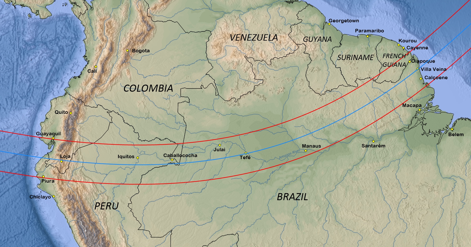
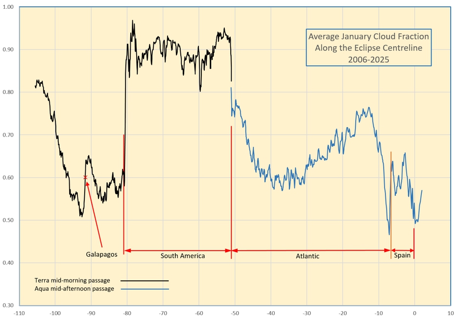
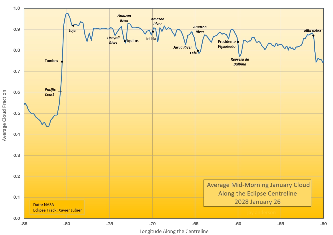
In Figure 5, cloud cover ranges between 80 and 90 percent along all but a small part of the shadow path. In the figure, the orange tones are veined by a dendritic network of lighter shades. This network outlines the rivers that cross the Amazon Basin. A large part of the cloudiness in January comes from convective buildups, and the larger rivers, being cooler than the surrounding landscape, suppresses the smaller convective elements, causing the average cloudiness to have a slightly lower value. This difference barely amounts to 10 percent, declining from 90 to 80 percent or thereabouts wherever the shadow path crosses a river. The graph of centreline cloudiness in Figure 6 shows the impact of the rivers in finer detail. The three Amazon River crossings bring modest declines but the largest is overtop the Represa de Balbina, a large reservoir on the Uatumã River near Presidente Figueiredo.
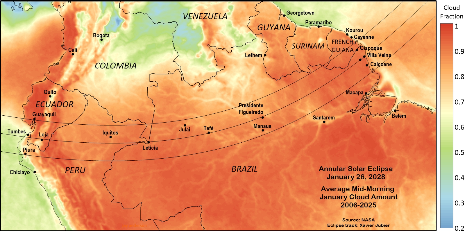
If there is any reason for optimism, it’s along the Pacific Coast where Figures 5 and 6 show a sharp drop in monthly cloudiness. Tumbes is the largest community in the area, but a short move to the coast will see cloud averages reduced by 15 percent on the centreline. The centreline cloud fraction of 0.6 (essentially 60%) can be reduced a little more by travelling southward toward Piura, where the cloud fraction drops to 0.55 and perhaps a little more, right on the coast. It’s not great, but it’s 25 percent lower than sites across the Amazon. Unfortunately, there are no sunshine measurements for Tumbes and Piura in Table1, and those over the Amazon Basin are very pessimistic, save for Iquitos.
The satellite animation for January 26, 2025 below gives a hint of a typical weather day across the Pacific coast and the Amazon Basin. Over the Basin, it’s highly convective, but also riddled with holes—there is actually a modest amount of sunshine. The flow is easterly, and the satellite loops show that cloud over the jungle does not cross the Andes, giving the Peruvian portion of the track its relatively cloud-free sky on this day. On eclipse day, some of the smaller cloud elements would likely dissipate as the air cools with the approach of the lunar shadow.
Animation of GOES E satellite images over South America on January 26, 2025. A large thunderstorm is visible in the lower right but the rest of the scene is mostly small convective clouds. Note that the flow of moist air across Brazil is blocked by the Andes before reaching the Pacific coast.
Scrutiny of the daily January 26 Terra satellite images from 2001 to 2025 offers a more down-to-earth impression of the prospects for a successful eclipse. Figure 7 shows a subjective evaluation of cloud cover on those 25 days (for some days, satellite photos were not available). The chances of being able to see the eclipse on those January 26s is evaluated for several locations. Keep in mind that it is a subjective evaluation and uses a limited set of satellite images.
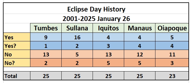
At Sullana (pop. 200,000), northeast of Piura, the eclipse could have been seen on 16 of the 25 years and possibly on 2 more, a frequency of over 70 percent. At the other sites, spread along the track, the likelihood of finding a view of the sun during eclipse ranges from 7 to 9 days on those 25 years.
Even though Sullana, Peru, is two-thirds of the distance from the centreline to the south limit, the city still offers over 5 ½ minutes of central eclipse. Moreover, there is a reasonably decent road network extending from the city that would allow some movement if patchy cloud is present, which is often the case. The subjective evaluation presented in Figure 7 is more optimistic than the satellite data suggest, but it’s a limited sample and should be viewed cautiously.
With skimpy sunshine prospects across much of South America, there is one destination on the continent for those more excited about adventure than viewing the eclipse. Iquitos, deep in the Peruvian jungles, is well-placed under the eclipse path and is popular for multi-day cruises on the Amazon and its nearby tributaries. Annular eclipses are forgiving of partly cloudy skies and Iquitos is not a lost cause: the sunshine data in Table 1 show that skies are bright on 42 percent of the daylight hours. An eclipse on the Amazon could be a very special eclipse journey, and even with cloud, the reaction of jungle animals will add a new dimension to the eclipse.
Madeira
The Portuguese island of Madeira presents an interesting challenge for the eclipse traveller. The sunshine statistic for Funchal in Table 2 is just fair to middling but the topography of the island presents some favourable opportunities. January is in the midst of the wet season in Madeira, but precipitation tends to come in short, heavy downpours. Funchal sunshine hours offer only a 50% chance of eclipse-viewing skies.
But Madeira is a hiker’s paradise with towering peaks offering spectacular panoramic views and world-famous hiking trails. For the eclipse traveller, the easily accessible heights offer an opportunity to get above the low cloud that typically surrounds the island. Foremost among these is Pico del Arieiro, easily reached by car and at an eclipse-promising altitude of 1800 m.
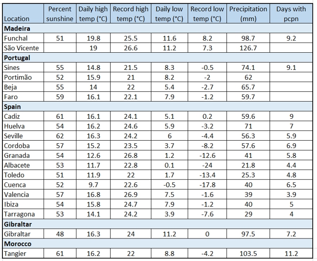
Figure 8 demonstrates that a view from Pico de Arieiro would have come with a more promising view of the sun on past January 26s , but the split between seeing and not seeing the eclipse is pretty close to 50/50 for both mountain and coastal sites. Much of the heavy weather in Madeira comes from cloud attached to storm systems that are passing farther to the north, and these are too large and deep for the mountain peaks to overcome. And, while the peaks offer a view from above some clouds, sea-level viewing sites looking across the ocean can sometimes see beneath the cloud cover to open skies offshore. A best option would be to select one site or the other on eclipse day, but decisions would have to be made early as it’s a long ride to the peaks on winding roads.
Iberian Peninsula
As the path of the Moon’s shadow comes toward its sunset ending in Spain, eclipsophiles must deal with the heavy cloudiness that comes with the winter season. The cloud-cover map of Figure 9 (which has an underlying topography) shows a patchwork quilt of cloudiness, with monthly average amounts ranging from 50 to 75 percent (0.50 to 0.70). The pattern of cloudiness mostly aligns with the terrain though the pattern is not the usual one. Along the eclipse track, the lowest levels of cloudiness are on the south-facing slopes of the higher terrain. This suggests that low- to mid-level cloudiness is eroded by northerly downslope winds.
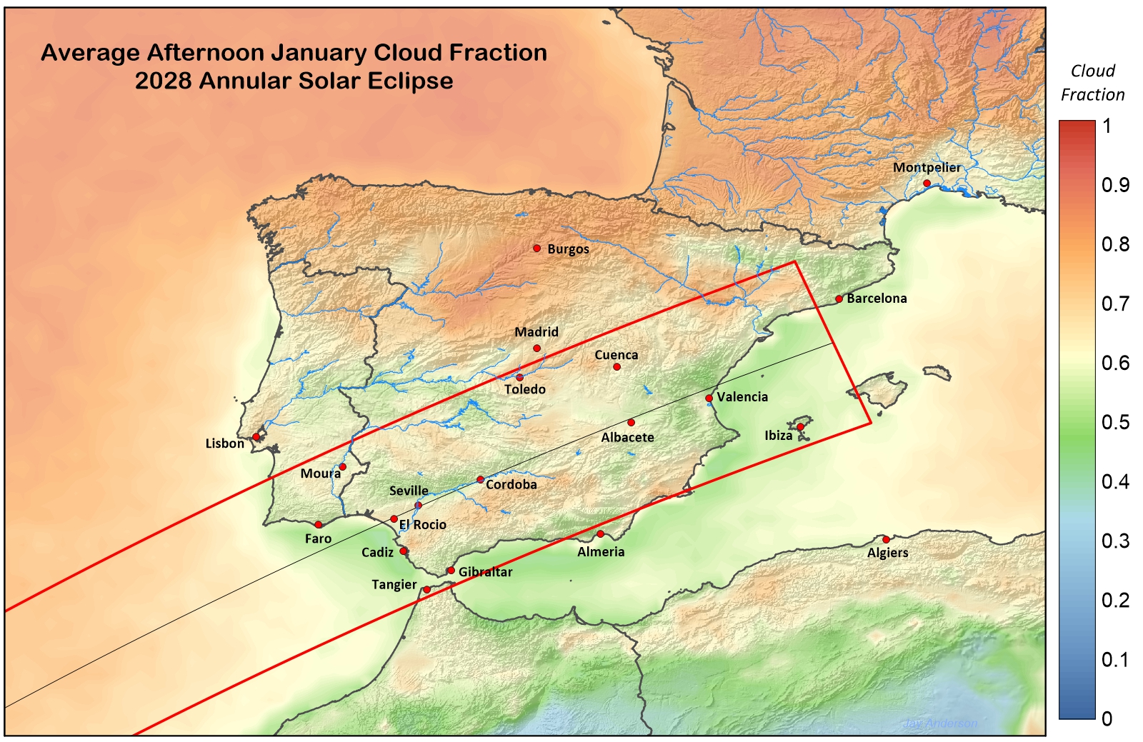
At Seville, which lies in the valley of the Guadalquivir River, lower cloud cover averages can be found a short distance to the north, on the south-facing slopes of the Sierra Morena. It’s not a large difference, only about 8 to 10 percent, but is suggests that on a day with low clouds and a northerly breeze, openings in the cloud might be found by moving toward the Sierra. At Cordoba, at a higher elevation and in a narrower part of the valley, the advantage gained by moving is only a few percent. Similar effects can be seen at Valencia, which also lies to the south of higher terrain, though it has the additional influence of the nearby Mediterranean to help out. Cadiz also benefits from an oceanside location; in fact the waters of the Gulf of Cadiz have the lowest cloud amount along the whole of the centreline (Figure 10), about 45 percent.
In Portugal, sunshine amounts and cloud behaviour are much the same as in Spain. The eclipse track passes over a terrain without a significant river valley and so the better weather is found along the coast. Ocean-front cloud amounts range around 55 percent, about 5 percent less than inland. Faro provides the most optimistic climatology, though by only a small amount.
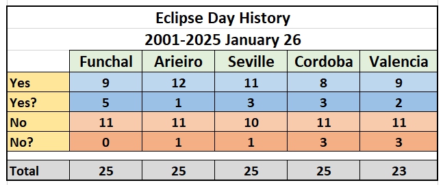
The sunshine data in Table 2 mimic the satellite measurements of cloud cover, with Faro, Cadiz, and Seville having the greatest amount of sunshine in the month, but only by a small amount compared to other Spanish and Portuguese locations. If observing from near the edge is your preference, then both Tangier in the south and Sines in the north have comparable sunshine averages. The eclipse-day history for three locations in Spain (Figure 8) are also discouraging, with more cloudy days than sunny, except in Seville.
Gibraltar is a bit of a cloud collector. Winter is a particularly windy time with the easterly Levanter often blowing at gale force—a situation that also tends to pile up the cloud against the Rock. Approaching cold fronts may bring a blustery southwest wind but after the front passes, a moderate westerly Poniente wind will bring a promise of clearer skies.
One critical factor that must be considered in selecting a location near the end of the track is the low elevation of the Sun at maximum eclipse. At Valencia, the Sun is only 2° above the horizon at maximum; at Albacete, it’s only a degree higher. From these locations in eastern Spain, any high-level cloud within 170-200 km will likely intrude on the view to the Sun. Even farther east, from Ibiza, only a location on the west coast of the island would have a view of the setting sun. However, if it proves to be clear, the view will be memorable.
When we look across the whole of the eclipse track (Figure 10), a few patterns stand out. Cloud cover is least over water and along the coastlines of both South America and Iberia. Cloud cover over the Amazon Basin is generally uniform, with a variation of only 10 or 15 percent around the 90 percent mark. In the Galapagos, the centreline passes south of the islands, but cloud conditions similar to the minimum on Figure 10 (~50%) can be found on the water west of Isabela and south of Fernandina.
This is an eclipse with a modest chance of success, even in the best places, and a limited ability to travel, except in Peru and the Iberian Peninsula.