Total Solar Eclipse
2021 December 4
This eclipse comes over a difficult area of the globe, with limited weather prospects and limited observing sites. In essence, there are only four places from which to view the event: from the Antarctic ice cap; from ship on the Southern Ocean, from the South Orkney Islands, or by air, flying from South America. All options are expensive.
Figure 1 outlines the cloud prospects along the track of the lunar shadow. Right away, it’s pretty obvious that a site on the ice cap has the best surface-based prospects for a clear-sky view of the Sun on eclipse day. Over the oceans, cloud cover averages more than 90%, as the coastline cannot be approached from the north because of the permanent floating ice over the Weddell Sea, which reaches most of the distance to the South Orkney Islands. In spite of this pessimistic tone, the situation for ship-board observers may not be as bleak as the cloud map would suggest.

Ship-board Observations
Realistically, eclipse observations from a cruise boat are only likely in the portion of the track between the South Georgia Islands and South Orkney Islands, along the route taken by boats crossing between the Falkland Islands and the Antarctic Peninsula. While some cruise companies advertise Weddell Sea destinations, these expeditions can only sail to the eastern side of the Antarctic Peninsula, which lies outside the path of totality. Ice conditions are too heavy (Figure 3) to allow anything but the largest icebreakers to reach the edge of the Filchner-Ronne Ice Shelf. While the map of average December cloud cover shows rather pessimistic conditions for the month, and the station data—what there is of it (Table 1)—confirms the frequent cloud cover, day to day satellite images are slightly more optimistic. With enough mobility and time, there are sometimes large areas with open or nearly open skies beneath the eclipse track that a ship can reach. The hard part is recognizing them early enough so that the ship can reach the right place.


In the two images in Figure 3, above, opportunities for a decent view of the eclipse are pretty limited. In 2017, the thin cloud cover north of the South Orkney Islands might provide a dim view of the Sun, though at 7° altitude, its elevation is so low that even thin clouds would block the sight line. In 2018, the opening in the cloud cover south of the Orkneys is promising, but requires a considerable deviation from the normal track between the Falklands and the Antarctic Peninsula. Only if the South Orkney Islands were a scheduled stop, then the open skies would be a welcome benefit.
The images in Figure 3 are somewhat pessimistic, as other dates close to eclipse day, and other years frequently show large areas of open sky that would be readily accessible by a ship. Some other examples can be seen in the satellite images in Figure 6.

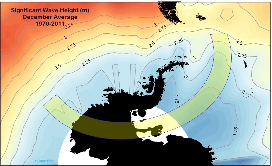
The Southern Ocean is justifiably famous for its bad weather, high winds and large waves. Fortunately, ship-board observers may catch a bit of a break here, as the track crosses a portion of the ocean that has a smaller wave climatology than other parts at this latitude (Figure 4). Over much of the reachable part of the track, significant wave heights (SWH) average from 1.75 m to 2.5 m. The SWH is traditionally defined as the average of the highest third of the trough-to-crest wave height. It’s not the highest wave that might be expected: about 1 in 100 will be 50% larger and passing storms can generate much higher waves.
The South Orkney Islands

The South Orkneys, like most island groups in the Southern Ocean, are rugged and mountainous (Figure 5), so that eclipse expeditions may be able to take advantage of the lee side clearing that typically comes with flow over higher terrain. As the air descends on the downwind side, the air is compressed and warmed, lowering the relative humidity and often clearing low- and mid-level cloud that might be present in the flow. On the South Orkney Islands, this is usually the north side, as prevailing winds are from the west.
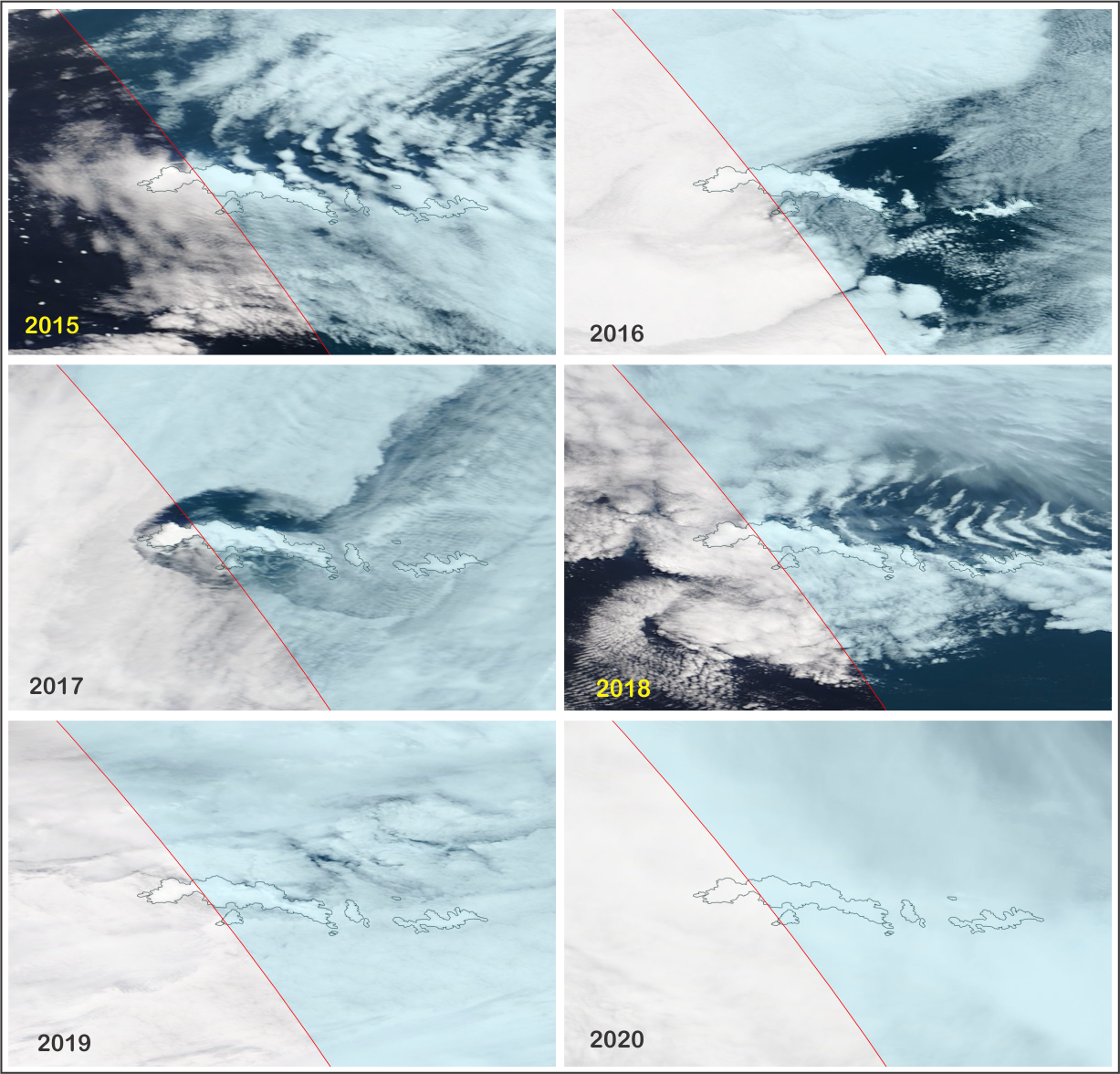
Figure 6 shows six satellite images of the South Orkneys on eclipse day spread across the years from 2015 to 2018. On all of these images, lee-side clearing is evident, though it complicated in two of the examples by wave clouds that have been generated by the cross-mountain flow. A ship-board expedition could decide on a “better safe than sorry” choice of these islands as a place to watch the eclipse, though it comes with a significant time penalty (a one-minute eclipse) and a low sun angle (around 8 degrees). A ship would have to lie offshore with a good-weather view toward the southeast to see the eclipse.
Noteworthy in Figure 6 is the presence of clear skies farther from the islands not related to the flow over the terrain that provide viewing other opportunities. The utility of these openings will depend on the ship’s mobility and the ability to find these spots given the limited satellite coverage at such low latitudes. Model forecasts may not be too useful since most of the cloud is in the hard-to-forecast lower levels.
The Antarctic Ice Cap
The only seasonal viewing site on the ice cap is that operated by Antarctic Logistics and Expeditions at Union Glacier, about 25 km inside the zone of totality. At the camp, the eclipsed Sun is about 14 degrees high and the eclipse duration is a meagre 46 seconds, but the weather prospects are better than any other easily approachable site along the path. The Union Glacier Camp is the only reliably inhabited site within the track over Antarctica and only one of three more-or-less guaranteed to have a human presence on December 4, 2021 (the others are the British Signy base and the Argentinian Orcadas base, both on the South Orkney Islands).
The eclipse comes during the nighttime hours at Union Glacier, but at 79 degrees south, daylight stretches through 24 hours. The view over the mountains surrounding the campsite can be improved by moving slightly to the northwest (Figure 7) or to other sites with a good southeast view.

Links
ALE Union Glacier camp: https://antarctic-logistics.com/camp/union-glacier-camp/
MODIS satellite images: https://worldview.earthdata.nasa.gov/